You are here: Home > Network List > TA - USArray Transportable Network (new EarthScope stations) Stations List
> Station G31M Satah River, YT, CAN > Earthquake Result Viewer
G31M Satah River, YT, CAN - Earthquake Result Viewer
| Earthquake location: |
Xizang |
| Earthquake latitude/longitude: |
33.1/86.8 |
| Earthquake time(UTC): |
2020/07/22 (204) 20:07:19 GMT |
| Earthquake Depth: |
10 km |
| Earthquake Magnitude: |
6.3 mww |
| Earthquake Catalog/Contributor: |
NEIC PDE/us |
|
| Network: |
TA USArray Transportable Network (new EarthScope stations) |
| Station: |
G31M Satah River, YT, CAN |
| Lat/Lon: |
66.92 N/134.27 W |
| Elevation: |
61 m |
|
| Distance: |
75.5 deg |
| Az: |
15.53 deg |
| Baz: |
325.255 deg |
| Ray Param: |
0.05164781 |
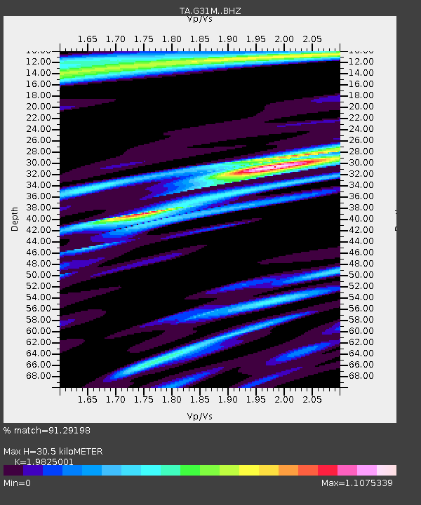
| Estimated Moho Depth: |
30.5 km |
| Estimated Crust Vp/Vs: |
1.98 |
| Assumed Crust Vp: |
6.171 km/s |
| Estimated Crust Vs: |
3.113 km/s |
| Estimated Crust Poisson's Ratio: |
0.33 |
|
| Radial Match: |
91.29198 % |
| Radial Bump: |
400 |
| Transverse Match: |
84.51376 % |
| Transverse Bump: |
400 |
| SOD ConfigId: |
21709731 |
| Insert Time: |
2020-08-05 20:26:18.499 +0000 |
| GWidth: |
2.5 |
| Max Bumps: |
400 |
| Tol: |
0.001 |
|

Signal To Noise
| Channel | StoN | STA | LTA |
| TA:G31M: :BHZ:20200722T20:18:32.449973Z | 41.101143 | 3.6846466E-6 | 8.9648275E-8 |
| TA:G31M: :BHN:20200722T20:18:32.449973Z | 13.434483 | 1.2596445E-6 | 9.376204E-8 |
| TA:G31M: :BHE:20200722T20:18:32.449973Z | 9.9897175 | 9.747346E-7 | 9.7573796E-8 |
| Arrivals |
| Ps | 5.0 SECOND |
| PpPs | 14 SECOND |
| PsPs/PpSs | 19 SECOND |


