You are here: Home > Network List > TA - USArray Transportable Network (new EarthScope stations) Stations List
> Station J14K Nanvaranak Lake, AK, USA > Earthquake Result Viewer
J14K Nanvaranak Lake, AK, USA - Earthquake Result Viewer
| Earthquake location: |
Xizang |
| Earthquake latitude/longitude: |
33.1/86.8 |
| Earthquake time(UTC): |
2020/07/22 (204) 20:07:19 GMT |
| Earthquake Depth: |
10 km |
| Earthquake Magnitude: |
6.3 mww |
| Earthquake Catalog/Contributor: |
NEIC PDE/us |
|
| Network: |
TA USArray Transportable Network (new EarthScope stations) |
| Station: |
J14K Nanvaranak Lake, AK, USA |
| Lat/Lon: |
62.75 N/163.55 W |
| Elevation: |
25 m |
|
| Distance: |
69.3 deg |
| Az: |
27.615 deg |
| Baz: |
302.335 deg |
| Ray Param: |
0.05573525 |
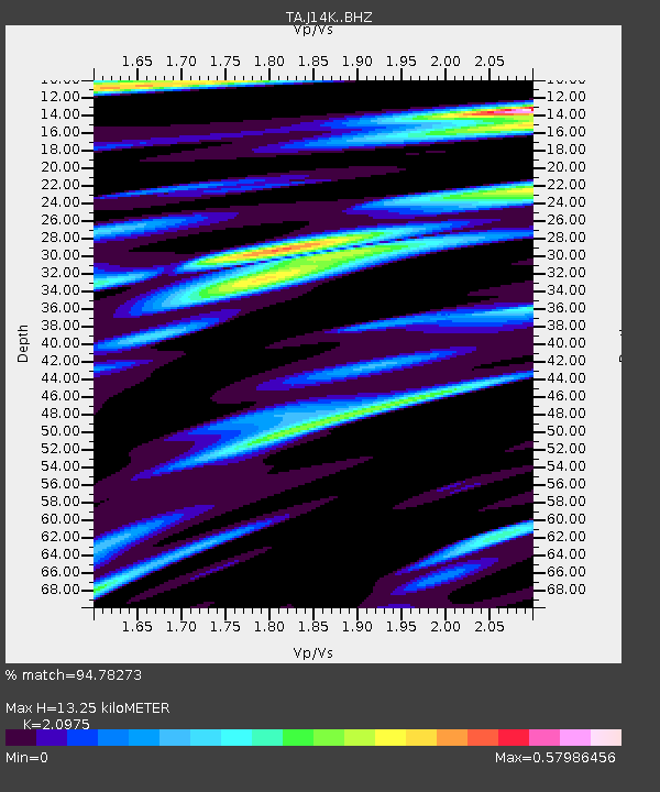
| Estimated Moho Depth: |
13.25 km |
| Estimated Crust Vp/Vs: |
2.10 |
| Assumed Crust Vp: |
6.155 km/s |
| Estimated Crust Vs: |
2.934 km/s |
| Estimated Crust Poisson's Ratio: |
0.35 |
|
| Radial Match: |
94.78273 % |
| Radial Bump: |
400 |
| Transverse Match: |
77.11918 % |
| Transverse Bump: |
400 |
| SOD ConfigId: |
21709731 |
| Insert Time: |
2020-08-05 20:26:37.924 +0000 |
| GWidth: |
2.5 |
| Max Bumps: |
400 |
| Tol: |
0.001 |
|

Signal To Noise
| Channel | StoN | STA | LTA |
| TA:J14K: :BHZ:20200722T20:17:55.724998Z | 57.332325 | 2.6129087E-6 | 4.557479E-8 |
| TA:J14K: :BHN:20200722T20:17:55.724998Z | 10.794759 | 5.2953396E-7 | 4.9054727E-8 |
| TA:J14K: :BHE:20200722T20:17:55.724998Z | 17.485664 | 9.1715947E-7 | 5.2452076E-8 |
| Arrivals |
| Ps | 2.4 SECOND |
| PpPs | 6.5 SECOND |
| PsPs/PpSs | 8.9 SECOND |


