You are here: Home > Network List > TA - USArray Transportable Network (new EarthScope stations) Stations List
> Station J16K Anvik River, AK, USA > Earthquake Result Viewer
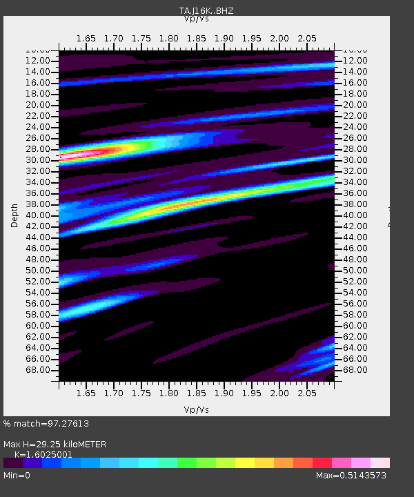
J16K Anvik River, AK, USA - Earthquake Result Viewer
| Earthquake location: |
Xizang |
| Earthquake latitude/longitude: |
33.1/86.8 |
| Earthquake time(UTC): |
2020/07/22 (204) 20:07:19 GMT |
| Earthquake Depth: |
10 km |
| Earthquake Magnitude: |
6.3 mww |
| Earthquake Catalog/Contributor: |
NEIC PDE/us |
|
| Network: |
TA USArray Transportable Network (new EarthScope stations) |
| Station: |
J16K Anvik River, AK, USA |
| Lat/Lon: |
63.28 N/160.60 W |
| Elevation: |
328 m |
|
| Distance: |
70.1 deg |
| Az: |
26.346 deg |
| Baz: |
304.522 deg |
| Ray Param: |
0.055198364 |
| Estimated Moho Depth: |
29.25 km |
| Estimated Crust Vp/Vs: |
1.60 |
| Assumed Crust Vp: |
6.276 km/s |
| Estimated Crust Vs: |
3.916 km/s |
| Estimated Crust Poisson's Ratio: |
0.18 |
|
| Radial Match: |
97.27613 % |
| Radial Bump: |
255 |
| Transverse Match: |
86.13261 % |
| Transverse Bump: |
400 |
| SOD ConfigId: |
21709731 |
| Insert Time: |
2020-08-05 20:26:38.657 +0000 |
| GWidth: |
2.5 |
| Max Bumps: |
400 |
| Tol: |
0.001 |
|

Signal To Noise
| Channel | StoN | STA | LTA |
| TA:J16K: :BHZ:20200722T20:18:00.824973Z | 37.416718 | 2.5840031E-6 | 6.906013E-8 |
| TA:J16K: :BHN:20200722T20:18:00.824973Z | 11.903843 | 5.8960484E-7 | 4.953063E-8 |
| TA:J16K: :BHE:20200722T20:18:00.824973Z | 21.79339 | 8.3121995E-7 | 3.814092E-8 |
| Arrivals |
| Ps | 2.9 SECOND |
| PpPs | 12 SECOND |
| PsPs/PpSs | 15 SECOND |


