You are here: Home > Network List > TA - USArray Transportable Network (new EarthScope stations) Stations List
> Station M31M Drury Creek, Yukon, CA > Earthquake Result Viewer
M31M Drury Creek, Yukon, CA - Earthquake Result Viewer
| Earthquake location: |
Xizang |
| Earthquake latitude/longitude: |
33.1/86.8 |
| Earthquake time(UTC): |
2020/07/22 (204) 20:07:19 GMT |
| Earthquake Depth: |
10 km |
| Earthquake Magnitude: |
6.3 mww |
| Earthquake Catalog/Contributor: |
NEIC PDE/us |
|
| Network: |
TA USArray Transportable Network (new EarthScope stations) |
| Station: |
M31M Drury Creek, Yukon, CA |
| Lat/Lon: |
62.20 N/134.39 W |
| Elevation: |
639 m |
|
| Distance: |
79.4 deg |
| Az: |
18.324 deg |
| Baz: |
325.756 deg |
| Ray Param: |
0.049021274 |
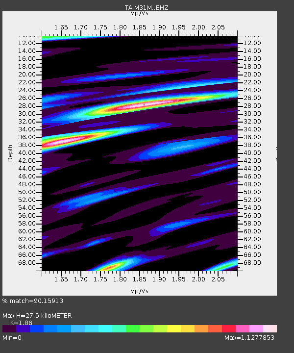
| Estimated Moho Depth: |
27.5 km |
| Estimated Crust Vp/Vs: |
1.86 |
| Assumed Crust Vp: |
6.419 km/s |
| Estimated Crust Vs: |
3.451 km/s |
| Estimated Crust Poisson's Ratio: |
0.30 |
|
| Radial Match: |
90.15913 % |
| Radial Bump: |
400 |
| Transverse Match: |
80.09912 % |
| Transverse Bump: |
400 |
| SOD ConfigId: |
21709731 |
| Insert Time: |
2020-08-05 20:27:12.968 +0000 |
| GWidth: |
2.5 |
| Max Bumps: |
400 |
| Tol: |
0.001 |
|
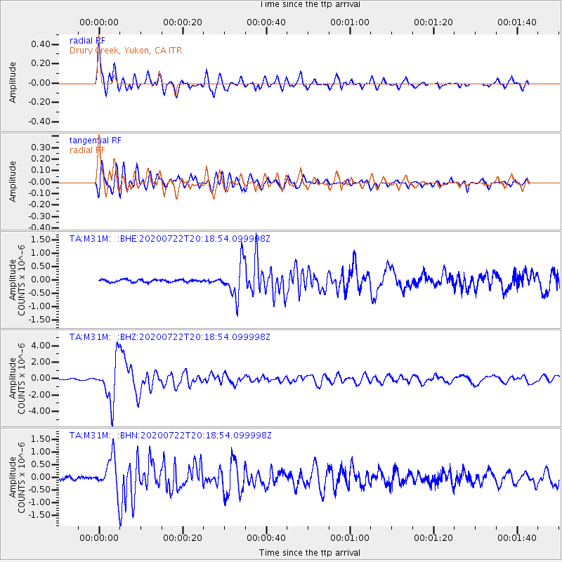
Signal To Noise
| Channel | StoN | STA | LTA |
| TA:M31M: :BHZ:20200722T20:18:54.099998Z | 60.2093 | 2.601761E-6 | 4.3211948E-8 |
| TA:M31M: :BHN:20200722T20:18:54.099998Z | 15.154423 | 6.91653E-7 | 4.564034E-8 |
| TA:M31M: :BHE:20200722T20:18:54.099998Z | 14.808466 | 6.5036505E-7 | 4.391846E-8 |
| Arrivals |
| Ps | 3.8 SECOND |
| PpPs | 12 SECOND |
| PsPs/PpSs | 16 SECOND |


