You are here: Home > Network List > GE - GEOFON Stations List
> Station SUMG GEOFON Station Summit Camp, Greenland > Earthquake Result Viewer
SUMG GEOFON Station Summit Camp, Greenland - Earthquake Result Viewer
| Earthquake location: |
Alaska Peninsula |
| Earthquake latitude/longitude: |
55.2/-159.3 |
| Earthquake time(UTC): |
2020/07/22 (204) 21:39:59 GMT |
| Earthquake Depth: |
39 km |
| Earthquake Magnitude: |
5.5 Mww |
| Earthquake Catalog/Contributor: |
NEIC PDE/us |
|
| Network: |
GE GEOFON |
| Station: |
SUMG GEOFON Station Summit Camp, Greenland |
| Lat/Lon: |
72.57 N/38.46 W |
| Elevation: |
3200 m |
|
| Distance: |
46.1 deg |
| Az: |
21.028 deg |
| Baz: |
316.973 deg |
| Ray Param: |
0.070764415 |
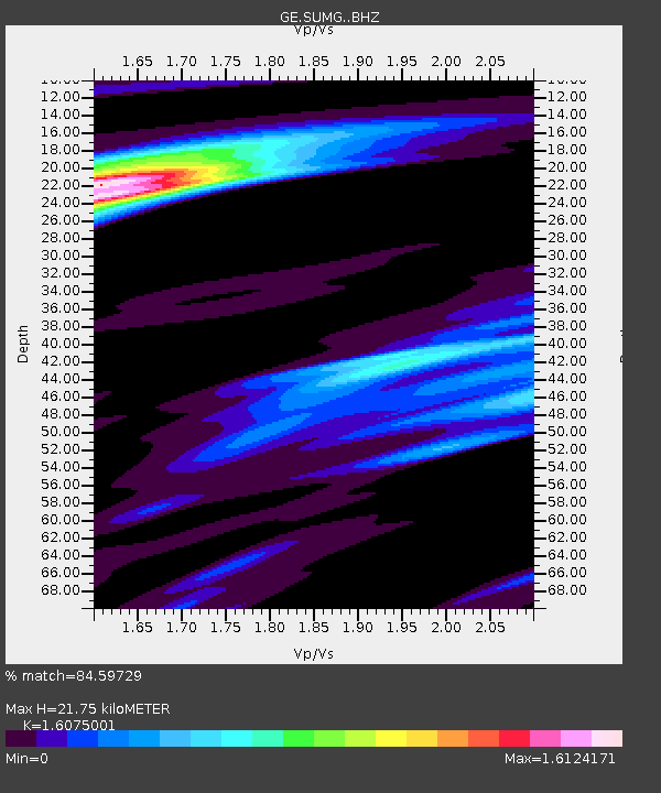
| Estimated Moho Depth: |
21.75 km |
| Estimated Crust Vp/Vs: |
1.61 |
| Assumed Crust Vp: |
6.261 km/s |
| Estimated Crust Vs: |
3.895 km/s |
| Estimated Crust Poisson's Ratio: |
0.18 |
|
| Radial Match: |
84.59729 % |
| Radial Bump: |
400 |
| Transverse Match: |
65.164116 % |
| Transverse Bump: |
400 |
| SOD ConfigId: |
21709731 |
| Insert Time: |
2020-08-05 21:46:10.774 +0000 |
| GWidth: |
2.5 |
| Max Bumps: |
400 |
| Tol: |
0.001 |
|

Signal To Noise
| Channel | StoN | STA | LTA |
| GE:SUMG: :BHZ:20200722T21:47:49.194986Z | 7.206402 | 1.3286373E-6 | 1.8436901E-7 |
| GE:SUMG: :BHN:20200722T21:47:49.194986Z | 2.2243214 | 3.4124233E-7 | 1.5341413E-7 |
| GE:SUMG: :BHE:20200722T21:47:49.194986Z | 5.4877357 | 5.8356966E-7 | 1.063407E-7 |
| Arrivals |
| Ps | 2.3 SECOND |
| PpPs | 8.5 SECOND |
| PsPs/PpSs | 11 SECOND |


