You are here: Home > Network List > US - United States National Seismic Network Stations List
> Station WMOK Wichita Mountains, Oklahoma, USA > Earthquake Result Viewer
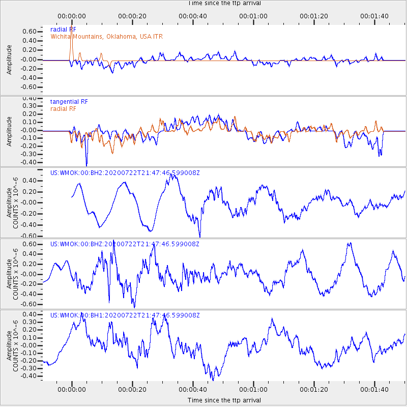
WMOK Wichita Mountains, Oklahoma, USA - Earthquake Result Viewer
*The percent match for this event was below the threshold and hence no stack was calculated.
| Earthquake location: |
Alaska Peninsula |
| Earthquake latitude/longitude: |
55.2/-159.3 |
| Earthquake time(UTC): |
2020/07/22 (204) 21:39:59 GMT |
| Earthquake Depth: |
39 km |
| Earthquake Magnitude: |
5.5 Mww |
| Earthquake Catalog/Contributor: |
NEIC PDE/us |
|
| Network: |
US United States National Seismic Network |
| Station: |
WMOK Wichita Mountains, Oklahoma, USA |
| Lat/Lon: |
34.74 N/98.78 W |
| Elevation: |
486 m |
|
| Distance: |
45.8 deg |
| Az: |
90.569 deg |
| Baz: |
315.918 deg |
| Ray Param: |
$rayparam |
*The percent match for this event was below the threshold and hence was not used in the summary stack. |
|
| Radial Match: |
47.897846 % |
| Radial Bump: |
400 |
| Transverse Match: |
48.58673 % |
| Transverse Bump: |
400 |
| SOD ConfigId: |
21709731 |
| Insert Time: |
2020-08-05 21:57:55.307 +0000 |
| GWidth: |
2.5 |
| Max Bumps: |
400 |
| Tol: |
0.001 |
|
Signal To Noise
| Channel | StoN | STA | LTA |
| US:WMOK:00:BHZ:20200722T21:47:46.599008Z | 1.1688297 | 1.7702736E-7 | 1.5145693E-7 |
| US:WMOK:00:BH1:20200722T21:47:46.599008Z | 6.340586 | 4.3471593E-7 | 6.856084E-8 |
| US:WMOK:00:BH2:20200722T21:47:46.599008Z | 1.5007021 | 3.9380868E-7 | 2.6241628E-7 |
| Arrivals |
| Ps | |
| PpPs | |
| PsPs/PpSs | |


