You are here: Home > Network List > WY - Yellowstone Wyoming Seismic Network Stations List
> Station YHR Hawk's Rest, WY, USA > Earthquake Result Viewer
YHR Hawk's Rest, WY, USA - Earthquake Result Viewer
| Earthquake location: |
Alaska Peninsula |
| Earthquake latitude/longitude: |
55.2/-159.3 |
| Earthquake time(UTC): |
2020/07/22 (204) 21:39:59 GMT |
| Earthquake Depth: |
39 km |
| Earthquake Magnitude: |
5.5 Mww |
| Earthquake Catalog/Contributor: |
NEIC PDE/us |
|
| Network: |
WY Yellowstone Wyoming Seismic Network |
| Station: |
YHR Hawk's Rest, WY, USA |
| Lat/Lon: |
44.11 N/110.08 W |
| Elevation: |
2976 m |
|
| Distance: |
33.1 deg |
| Az: |
88.763 deg |
| Baz: |
307.329 deg |
| Ray Param: |
0.07831314 |
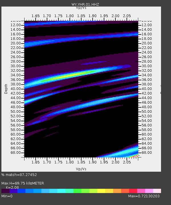
| Estimated Moho Depth: |
69.75 km |
| Estimated Crust Vp/Vs: |
2.08 |
| Assumed Crust Vp: |
6.35 km/s |
| Estimated Crust Vs: |
3.053 km/s |
| Estimated Crust Poisson's Ratio: |
0.35 |
|
| Radial Match: |
87.27452 % |
| Radial Bump: |
165 |
| Transverse Match: |
69.00656 % |
| Transverse Bump: |
310 |
| SOD ConfigId: |
21709731 |
| Insert Time: |
2020-08-05 21:58:53.384 +0000 |
| GWidth: |
2.5 |
| Max Bumps: |
400 |
| Tol: |
0.001 |
|
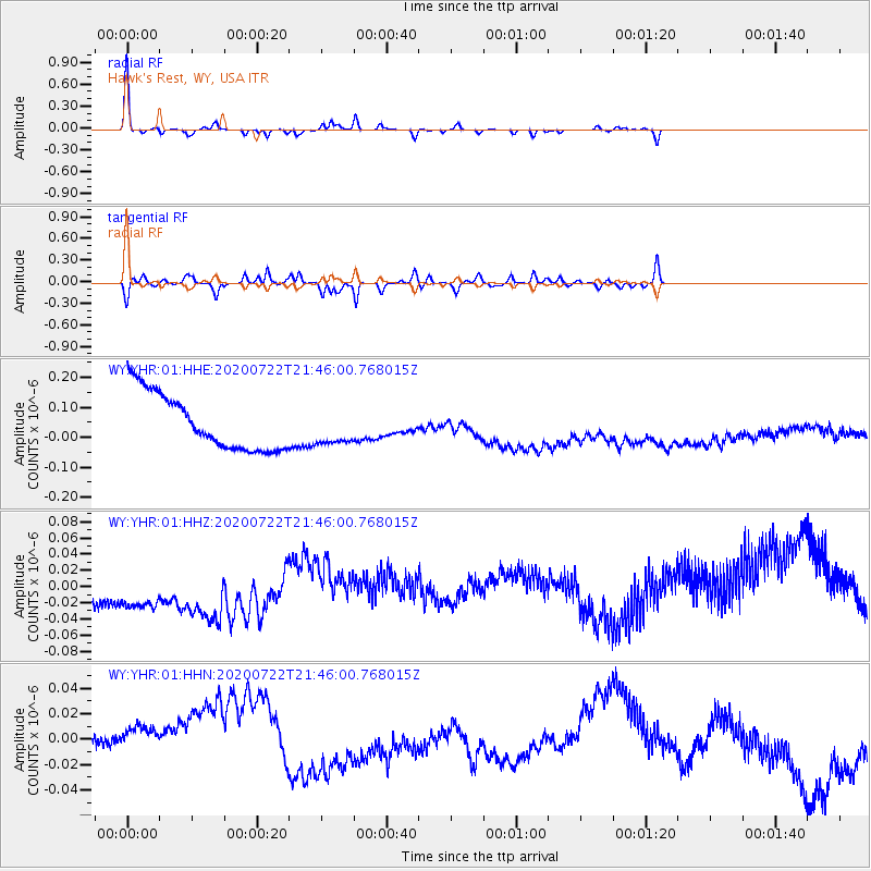
Signal To Noise
| Channel | StoN | STA | LTA |
| WY:YHR:01:HHZ:20200722T21:46:00.768015Z | 1.4423735 | 7.729031E-8 | 5.35855E-8 |
| WY:YHR:01:HHN:20200722T21:46:00.768015Z | 1.070752 | 2.1814332E-8 | 2.0372907E-8 |
| WY:YHR:01:HHE:20200722T21:46:00.768015Z | 0.6243985 | 5.855623E-8 | 9.3780216E-8 |
| Arrivals |
| Ps | 13 SECOND |
| PpPs | 32 SECOND |
| PsPs/PpSs | 44 SECOND |


