You are here: Home > Network List > US - United States National Seismic Network Stations List
> Station DUG Dugway, Tooele County, Utah, USA > Earthquake Result Viewer
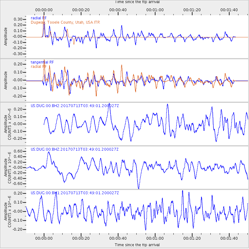
DUG Dugway, Tooele County, Utah, USA - Earthquake Result Viewer
*The percent match for this event was below the threshold and hence no stack was calculated.
| Earthquake location: |
New Ireland Region, P.N.G. |
| Earthquake latitude/longitude: |
-4.8/153.2 |
| Earthquake time(UTC): |
2017/07/13 (194) 03:36:09 GMT |
| Earthquake Depth: |
47 km |
| Earthquake Magnitude: |
6.4 mww |
| Earthquake Catalog/Contributor: |
NEIC PDE/us |
|
| Network: |
US United States National Seismic Network |
| Station: |
DUG Dugway, Tooele County, Utah, USA |
| Lat/Lon: |
40.19 N/112.81 W |
| Elevation: |
1477 m |
|
| Distance: |
96.1 deg |
| Az: |
50.219 deg |
| Baz: |
268.933 deg |
| Ray Param: |
$rayparam |
*The percent match for this event was below the threshold and hence was not used in the summary stack. |
|
| Radial Match: |
64.281494 % |
| Radial Bump: |
400 |
| Transverse Match: |
59.5574 % |
| Transverse Bump: |
400 |
| SOD ConfigId: |
2140511 |
| Insert Time: |
2017-07-26 19:33:09.398 +0000 |
| GWidth: |
2.5 |
| Max Bumps: |
400 |
| Tol: |
0.001 |
|
Signal To Noise
| Channel | StoN | STA | LTA |
| US:DUG:00:BHZ:20170713T03:49:01.200027Z | 11.331054 | 3.185013E-7 | 2.810871E-8 |
| US:DUG:00:BH1:20170713T03:49:01.200027Z | 1.6070838 | 6.990478E-8 | 4.3497906E-8 |
| US:DUG:00:BH2:20170713T03:49:01.200027Z | 1.1129767 | 8.665799E-8 | 7.7861465E-8 |
| Arrivals |
| Ps | |
| PpPs | |
| PsPs/PpSs | |


