You are here: Home > Network List > US - United States National Seismic Network Stations List
> Station HLID Hailey, Idaho, USA > Earthquake Result Viewer
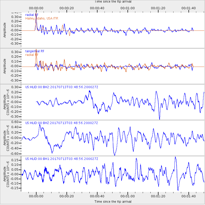
HLID Hailey, Idaho, USA - Earthquake Result Viewer
*The percent match for this event was below the threshold and hence no stack was calculated.
| Earthquake location: |
New Ireland Region, P.N.G. |
| Earthquake latitude/longitude: |
-4.8/153.2 |
| Earthquake time(UTC): |
2017/07/13 (194) 03:36:09 GMT |
| Earthquake Depth: |
47 km |
| Earthquake Magnitude: |
6.4 mww |
| Earthquake Catalog/Contributor: |
NEIC PDE/us |
|
| Network: |
US United States National Seismic Network |
| Station: |
HLID Hailey, Idaho, USA |
| Lat/Lon: |
43.56 N/114.41 W |
| Elevation: |
1772 m |
|
| Distance: |
95.0 deg |
| Az: |
46.809 deg |
| Baz: |
268.199 deg |
| Ray Param: |
$rayparam |
*The percent match for this event was below the threshold and hence was not used in the summary stack. |
|
| Radial Match: |
78.71881 % |
| Radial Bump: |
390 |
| Transverse Match: |
53.3499 % |
| Transverse Bump: |
400 |
| SOD ConfigId: |
2140511 |
| Insert Time: |
2017-07-26 19:33:21.877 +0000 |
| GWidth: |
2.5 |
| Max Bumps: |
400 |
| Tol: |
0.001 |
|
Signal To Noise
| Channel | StoN | STA | LTA |
| US:HLID:00:BHZ:20170713T03:48:56.200027Z | 6.3580146 | 3.0527957E-7 | 4.8014922E-8 |
| US:HLID:00:BH1:20170713T03:48:56.200027Z | 0.93422544 | 3.328077E-8 | 3.5623916E-8 |
| US:HLID:00:BH2:20170713T03:48:56.200027Z | 2.7968416 | 9.477308E-8 | 3.388575E-8 |
| Arrivals |
| Ps | |
| PpPs | |
| PsPs/PpSs | |


