You are here: Home > Network List > AV - Alaska Volcano Observatory Stations List
> Station ILLG Iliamna Volcano, Alaska > Earthquake Result Viewer
ILLG Iliamna Volcano, Alaska - Earthquake Result Viewer
| Earthquake location: |
Near Coast Of Oaxaca, Mexico |
| Earthquake latitude/longitude: |
15.6/-95.9 |
| Earthquake time(UTC): |
2020/07/24 (206) 03:19:51 GMT |
| Earthquake Depth: |
6.6 km |
| Earthquake Magnitude: |
5.5 mww |
| Earthquake Catalog/Contributor: |
NEIC PDE/us |
|
| Network: |
AV Alaska Volcano Observatory |
| Station: |
ILLG Iliamna Volcano, Alaska |
| Lat/Lon: |
60.07 N/152.96 W |
| Elevation: |
968 m |
|
| Distance: |
60.4 deg |
| Az: |
331.042 deg |
| Baz: |
111.52 deg |
| Ray Param: |
0.061583742 |
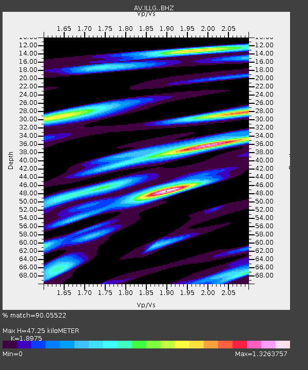
| Estimated Moho Depth: |
47.25 km |
| Estimated Crust Vp/Vs: |
1.90 |
| Assumed Crust Vp: |
6.566 km/s |
| Estimated Crust Vs: |
3.46 km/s |
| Estimated Crust Poisson's Ratio: |
0.31 |
|
| Radial Match: |
90.05522 % |
| Radial Bump: |
400 |
| Transverse Match: |
81.38963 % |
| Transverse Bump: |
400 |
| SOD ConfigId: |
21709731 |
| Insert Time: |
2020-08-07 03:23:57.064 +0000 |
| GWidth: |
2.5 |
| Max Bumps: |
400 |
| Tol: |
0.001 |
|

Signal To Noise
| Channel | StoN | STA | LTA |
| AV:ILLG: :BHZ:20200724T03:29:29.780023Z | 9.242121 | 3.7536012E-7 | 4.0614065E-8 |
| AV:ILLG: :BHN:20200724T03:29:29.780023Z | 2.5897539 | 1.6064268E-7 | 6.20301E-8 |
| AV:ILLG: :BHE:20200724T03:29:29.780023Z | 5.836907 | 2.7168156E-7 | 4.654547E-8 |
| Arrivals |
| Ps | 6.8 SECOND |
| PpPs | 20 SECOND |
| PsPs/PpSs | 27 SECOND |


