You are here: Home > Network List > AV - Alaska Volcano Observatory Stations List
> Station ILS Iliamna South, Iliamna Volcano, Alaska > Earthquake Result Viewer
ILS Iliamna South, Iliamna Volcano, Alaska - Earthquake Result Viewer
| Earthquake location: |
Near Coast Of Oaxaca, Mexico |
| Earthquake latitude/longitude: |
15.6/-95.9 |
| Earthquake time(UTC): |
2020/07/24 (206) 03:19:51 GMT |
| Earthquake Depth: |
6.6 km |
| Earthquake Magnitude: |
5.5 mww |
| Earthquake Catalog/Contributor: |
NEIC PDE/us |
|
| Network: |
AV Alaska Volcano Observatory |
| Station: |
ILS Iliamna South, Iliamna Volcano, Alaska |
| Lat/Lon: |
59.96 N/153.07 W |
| Elevation: |
1125 m |
|
| Distance: |
60.4 deg |
| Az: |
330.898 deg |
| Baz: |
111.354 deg |
| Ray Param: |
0.06157727 |
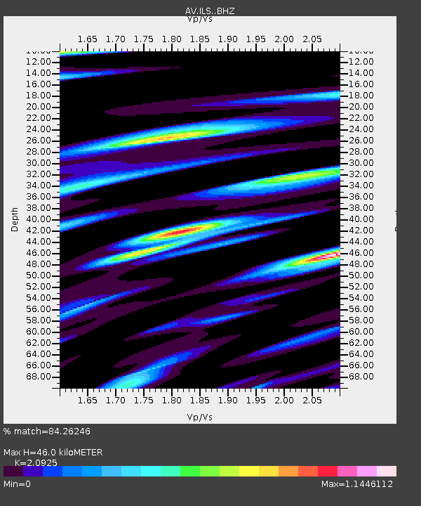
| Estimated Moho Depth: |
46.0 km |
| Estimated Crust Vp/Vs: |
2.09 |
| Assumed Crust Vp: |
5.989 km/s |
| Estimated Crust Vs: |
2.862 km/s |
| Estimated Crust Poisson's Ratio: |
0.35 |
|
| Radial Match: |
84.26246 % |
| Radial Bump: |
400 |
| Transverse Match: |
72.08461 % |
| Transverse Bump: |
400 |
| SOD ConfigId: |
21709731 |
| Insert Time: |
2020-08-07 03:23:57.602 +0000 |
| GWidth: |
2.5 |
| Max Bumps: |
400 |
| Tol: |
0.001 |
|
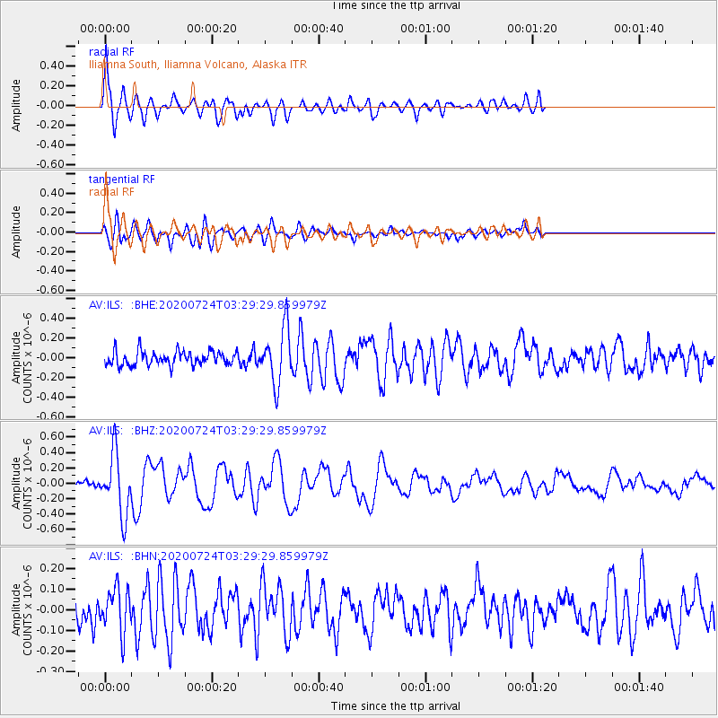
Signal To Noise
| Channel | StoN | STA | LTA |
| AV:ILS: :BHZ:20200724T03:29:29.859979Z | 7.9307113 | 3.9623964E-7 | 4.9962686E-8 |
| AV:ILS: :BHN:20200724T03:29:29.859979Z | 1.9721948 | 1.07449054E-7 | 5.448197E-8 |
| AV:ILS: :BHE:20200724T03:29:29.859979Z | 4.072924 | 2.8564912E-7 | 7.013367E-8 |
| Arrivals |
| Ps | 8.7 SECOND |
| PpPs | 23 SECOND |
| PsPs/PpSs | 32 SECOND |


