You are here: Home > Network List > CN - Canadian National Seismograph Network Stations List
> Station A16 Riviere Ouelle, QC, CA > Earthquake Result Viewer
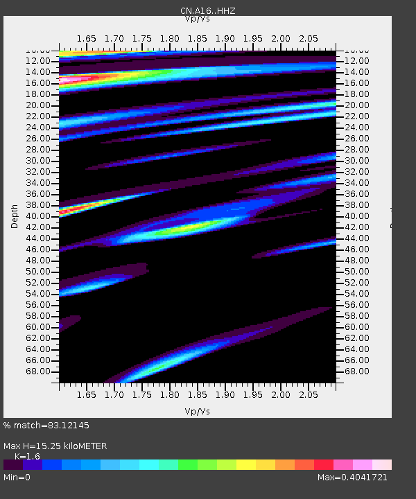
A16 Riviere Ouelle, QC, CA - Earthquake Result Viewer
| Earthquake location: |
Near Coast Of Oaxaca, Mexico |
| Earthquake latitude/longitude: |
15.6/-95.9 |
| Earthquake time(UTC): |
2020/07/24 (206) 03:19:51 GMT |
| Earthquake Depth: |
6.6 km |
| Earthquake Magnitude: |
5.5 mww |
| Earthquake Catalog/Contributor: |
NEIC PDE/us |
|
| Network: |
CN Canadian National Seismograph Network |
| Station: |
A16 Riviere Ouelle, QC, CA |
| Lat/Lon: |
47.47 N/70.01 W |
| Elevation: |
13 m |
|
| Distance: |
38.3 deg |
| Az: |
28.537 deg |
| Baz: |
222.722 deg |
| Ray Param: |
0.07567212 |
| Estimated Moho Depth: |
15.25 km |
| Estimated Crust Vp/Vs: |
1.60 |
| Assumed Crust Vp: |
6.61 km/s |
| Estimated Crust Vs: |
4.131 km/s |
| Estimated Crust Poisson's Ratio: |
0.18 |
|
| Radial Match: |
83.12145 % |
| Radial Bump: |
400 |
| Transverse Match: |
58.576374 % |
| Transverse Bump: |
400 |
| SOD ConfigId: |
21709731 |
| Insert Time: |
2020-08-07 03:27:37.853 +0000 |
| GWidth: |
2.5 |
| Max Bumps: |
400 |
| Tol: |
0.001 |
|

Signal To Noise
| Channel | StoN | STA | LTA |
| CN:A16: :HHZ:20200724T03:26:41.33999Z | 9.742631 | 8.675663E-7 | 8.904846E-8 |
| CN:A16: :HHN:20200724T03:26:41.33999Z | 2.9349961 | 3.6891728E-7 | 1.25696E-7 |
| CN:A16: :HHE:20200724T03:26:41.33999Z | 3.5173948 | 4.0542523E-7 | 1.1526293E-7 |
| Arrivals |
| Ps | 1.5 SECOND |
| PpPs | 5.5 SECOND |
| PsPs/PpSs | 7.0 SECOND |


