You are here: Home > Network List > CN - Canadian National Seismograph Network Stations List
> Station BLKN Baker Lake, NU, CA > Earthquake Result Viewer
BLKN Baker Lake, NU, CA - Earthquake Result Viewer
| Earthquake location: |
Near Coast Of Oaxaca, Mexico |
| Earthquake latitude/longitude: |
15.6/-95.9 |
| Earthquake time(UTC): |
2020/07/24 (206) 03:19:51 GMT |
| Earthquake Depth: |
6.6 km |
| Earthquake Magnitude: |
5.5 mww |
| Earthquake Catalog/Contributor: |
NEIC PDE/us |
|
| Network: |
CN Canadian National Seismograph Network |
| Station: |
BLKN Baker Lake, NU, CA |
| Lat/Lon: |
64.32 N/96.00 W |
| Elevation: |
40 m |
|
| Distance: |
48.6 deg |
| Az: |
359.932 deg |
| Baz: |
179.849 deg |
| Ray Param: |
0.06923834 |
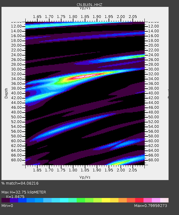
| Estimated Moho Depth: |
32.75 km |
| Estimated Crust Vp/Vs: |
1.85 |
| Assumed Crust Vp: |
6.459 km/s |
| Estimated Crust Vs: |
3.496 km/s |
| Estimated Crust Poisson's Ratio: |
0.29 |
|
| Radial Match: |
84.06216 % |
| Radial Bump: |
300 |
| Transverse Match: |
55.411304 % |
| Transverse Bump: |
400 |
| SOD ConfigId: |
21709731 |
| Insert Time: |
2020-08-07 03:27:50.329 +0000 |
| GWidth: |
2.5 |
| Max Bumps: |
400 |
| Tol: |
0.001 |
|

Signal To Noise
| Channel | StoN | STA | LTA |
| CN:BLKN: :HHZ:20200724T03:28:04.629999Z | 8.65999 | 1.0858201E-6 | 1.2538352E-7 |
| CN:BLKN: :HHN:20200724T03:28:04.629999Z | 6.610783 | 5.657147E-7 | 8.5574534E-8 |
| CN:BLKN: :HHE:20200724T03:28:04.629999Z | 1.2282556 | 1.0323212E-7 | 8.404775E-8 |
| Arrivals |
| Ps | 4.6 SECOND |
| PpPs | 14 SECOND |
| PsPs/PpSs | 18 SECOND |


