You are here: Home > Network List > CN - Canadian National Seismograph Network Stations List
> Station KILO Kirkland Lake, ON, CA > Earthquake Result Viewer
KILO Kirkland Lake, ON, CA - Earthquake Result Viewer
| Earthquake location: |
Near Coast Of Oaxaca, Mexico |
| Earthquake latitude/longitude: |
15.6/-95.9 |
| Earthquake time(UTC): |
2020/07/24 (206) 03:19:51 GMT |
| Earthquake Depth: |
6.6 km |
| Earthquake Magnitude: |
5.5 mww |
| Earthquake Catalog/Contributor: |
NEIC PDE/us |
|
| Network: |
CN Canadian National Seismograph Network |
| Station: |
KILO Kirkland Lake, ON, CA |
| Lat/Lon: |
48.50 N/79.72 W |
| Elevation: |
314 m |
|
| Distance: |
35.4 deg |
| Az: |
18.651 deg |
| Baz: |
207.598 deg |
| Ray Param: |
0.07726565 |
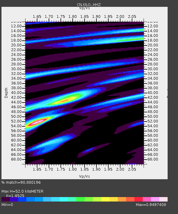
| Estimated Moho Depth: |
52.0 km |
| Estimated Crust Vp/Vs: |
1.65 |
| Assumed Crust Vp: |
6.61 km/s |
| Estimated Crust Vs: |
4.0 km/s |
| Estimated Crust Poisson's Ratio: |
0.21 |
|
| Radial Match: |
90.880196 % |
| Radial Bump: |
328 |
| Transverse Match: |
58.92292 % |
| Transverse Bump: |
400 |
| SOD ConfigId: |
21709731 |
| Insert Time: |
2020-08-07 03:28:52.349 +0000 |
| GWidth: |
2.5 |
| Max Bumps: |
400 |
| Tol: |
0.001 |
|

Signal To Noise
| Channel | StoN | STA | LTA |
| CN:KILO: :HHZ:20200724T03:26:16.480005Z | 8.446397 | 1.161783E-6 | 1.3754776E-7 |
| CN:KILO: :HHN:20200724T03:26:16.480005Z | 6.142286 | 6.3221535E-7 | 1.0292835E-7 |
| CN:KILO: :HHE:20200724T03:26:16.480005Z | 3.5994046 | 2.7734418E-7 | 7.7052796E-8 |
| Arrivals |
| Ps | 5.6 SECOND |
| PpPs | 19 SECOND |
| PsPs/PpSs | 25 SECOND |


