You are here: Home > Network List > CN - Canadian National Seismograph Network Stations List
> Station MGRB Mount Grey, BC, CA > Earthquake Result Viewer
MGRB Mount Grey, BC, CA - Earthquake Result Viewer
| Earthquake location: |
Near Coast Of Oaxaca, Mexico |
| Earthquake latitude/longitude: |
15.6/-95.9 |
| Earthquake time(UTC): |
2020/07/24 (206) 03:19:51 GMT |
| Earthquake Depth: |
6.6 km |
| Earthquake Magnitude: |
5.5 mww |
| Earthquake Catalog/Contributor: |
NEIC PDE/us |
|
| Network: |
CN Canadian National Seismograph Network |
| Station: |
MGRB Mount Grey, BC, CA |
| Lat/Lon: |
49.00 N/124.70 W |
| Elevation: |
1310 m |
|
| Distance: |
40.8 deg |
| Az: |
330.919 deg |
| Baz: |
134.673 deg |
| Ray Param: |
0.07421637 |
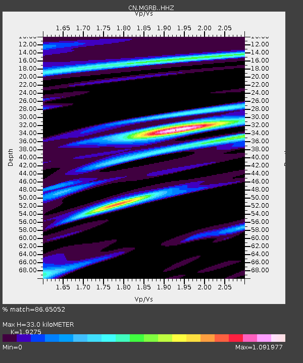
| Estimated Moho Depth: |
33.0 km |
| Estimated Crust Vp/Vs: |
1.93 |
| Assumed Crust Vp: |
6.391 km/s |
| Estimated Crust Vs: |
3.315 km/s |
| Estimated Crust Poisson's Ratio: |
0.32 |
|
| Radial Match: |
86.65052 % |
| Radial Bump: |
320 |
| Transverse Match: |
59.530193 % |
| Transverse Bump: |
400 |
| SOD ConfigId: |
21709731 |
| Insert Time: |
2020-08-07 03:29:02.282 +0000 |
| GWidth: |
2.5 |
| Max Bumps: |
400 |
| Tol: |
0.001 |
|

Signal To Noise
| Channel | StoN | STA | LTA |
| CN:MGRB: :HHZ:20200724T03:27:01.869989Z | 3.1613445 | 4.507895E-7 | 1.4259423E-7 |
| CN:MGRB: :HHN:20200724T03:27:01.869989Z | 1.0222981 | 2.725351E-7 | 2.665906E-7 |
| CN:MGRB: :HHE:20200724T03:27:01.869989Z | 1.2624749 | 3.0643224E-7 | 2.4272342E-7 |
| Arrivals |
| Ps | 5.1 SECOND |
| PpPs | 14 SECOND |
| PsPs/PpSs | 19 SECOND |


