You are here: Home > Network List > TA - USArray Transportable Network (new EarthScope stations) Stations List
> Station D23K Nanushuk River, AK USA > Earthquake Result Viewer
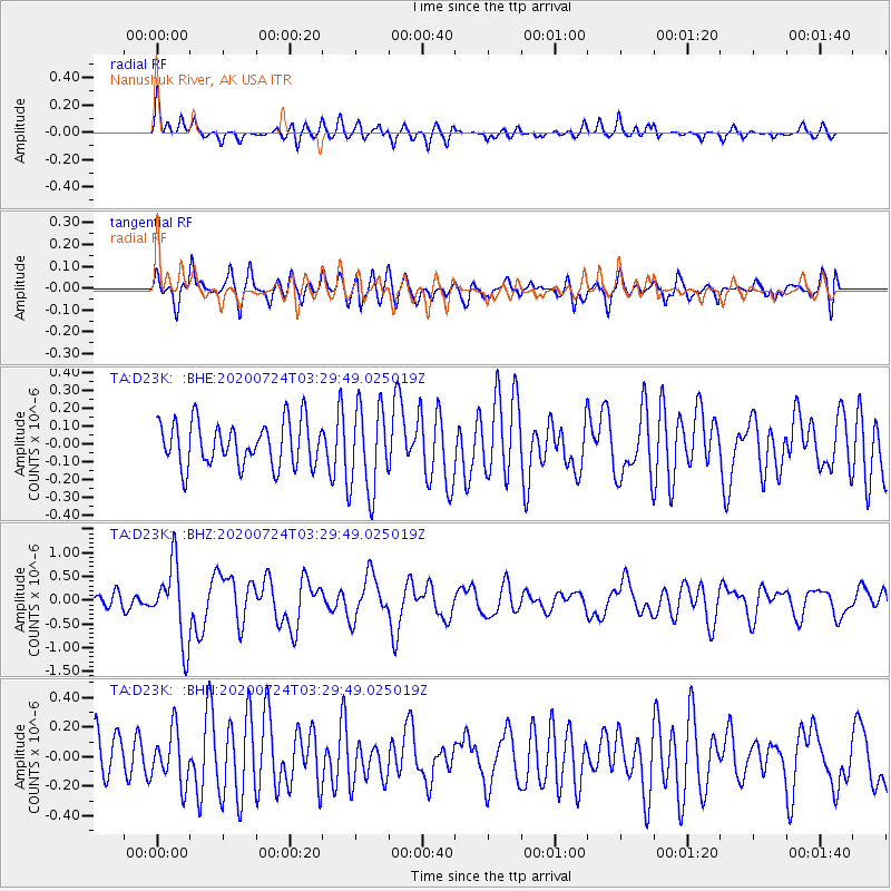
D23K Nanushuk River, AK USA - Earthquake Result Viewer
*The percent match for this event was below the threshold and hence no stack was calculated.
| Earthquake location: |
Near Coast Of Oaxaca, Mexico |
| Earthquake latitude/longitude: |
15.6/-95.9 |
| Earthquake time(UTC): |
2020/07/24 (206) 03:19:51 GMT |
| Earthquake Depth: |
6.6 km |
| Earthquake Magnitude: |
5.5 mww |
| Earthquake Catalog/Contributor: |
NEIC PDE/us |
|
| Network: |
TA USArray Transportable Network (new EarthScope stations) |
| Station: |
D23K Nanushuk River, AK USA |
| Lat/Lon: |
68.97 N/150.68 W |
| Elevation: |
406 m |
|
| Distance: |
63.3 deg |
| Az: |
340.71 deg |
| Baz: |
118.158 deg |
| Ray Param: |
$rayparam |
*The percent match for this event was below the threshold and hence was not used in the summary stack. |
|
| Radial Match: |
61.917934 % |
| Radial Bump: |
355 |
| Transverse Match: |
64.758484 % |
| Transverse Bump: |
400 |
| SOD ConfigId: |
21709731 |
| Insert Time: |
2020-08-07 03:36:59.041 +0000 |
| GWidth: |
2.5 |
| Max Bumps: |
400 |
| Tol: |
0.001 |
|
Signal To Noise
| Channel | StoN | STA | LTA |
| TA:D23K: :BHZ:20200724T03:29:49.025019Z | 5.310771 | 8.0816733E-7 | 1.5217513E-7 |
| TA:D23K: :BHN:20200724T03:29:49.025019Z | 0.92050344 | 1.7690367E-7 | 1.9218143E-7 |
| TA:D23K: :BHE:20200724T03:29:49.025019Z | 1.9579077 | 2.4009822E-7 | 1.2262998E-7 |
| Arrivals |
| Ps | |
| PpPs | |
| PsPs/PpSs | |


