You are here: Home > Network List > TA - USArray Transportable Network (new EarthScope stations) Stations List
> Station H27K Steamboat Mountain, AK, USA > Earthquake Result Viewer
H27K Steamboat Mountain, AK, USA - Earthquake Result Viewer
| Earthquake location: |
Near Coast Of Oaxaca, Mexico |
| Earthquake latitude/longitude: |
15.6/-95.9 |
| Earthquake time(UTC): |
2020/07/24 (206) 03:19:51 GMT |
| Earthquake Depth: |
6.6 km |
| Earthquake Magnitude: |
5.5 mww |
| Earthquake Catalog/Contributor: |
NEIC PDE/us |
|
| Network: |
TA USArray Transportable Network (new EarthScope stations) |
| Station: |
H27K Steamboat Mountain, AK, USA |
| Lat/Lon: |
66.23 N/141.53 W |
| Elevation: |
786 m |
|
| Distance: |
58.8 deg |
| Az: |
340.201 deg |
| Baz: |
126.371 deg |
| Ray Param: |
0.062599555 |
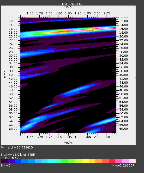
| Estimated Moho Depth: |
16.0 km |
| Estimated Crust Vp/Vs: |
1.98 |
| Assumed Crust Vp: |
6.577 km/s |
| Estimated Crust Vs: |
3.33 km/s |
| Estimated Crust Poisson's Ratio: |
0.33 |
|
| Radial Match: |
90.423615 % |
| Radial Bump: |
400 |
| Transverse Match: |
73.74823 % |
| Transverse Bump: |
400 |
| SOD ConfigId: |
21709731 |
| Insert Time: |
2020-08-07 03:38:09.623 +0000 |
| GWidth: |
2.5 |
| Max Bumps: |
400 |
| Tol: |
0.001 |
|

Signal To Noise
| Channel | StoN | STA | LTA |
| TA:H27K: :BHZ:20200724T03:29:19.025019Z | 14.415034 | 6.2127447E-7 | 4.3099064E-8 |
| TA:H27K: :BHN:20200724T03:29:19.025019Z | 5.462698 | 2.0566752E-7 | 3.764944E-8 |
| TA:H27K: :BHE:20200724T03:29:19.025019Z | 3.716497 | 2.1489409E-7 | 5.7821676E-8 |
| Arrivals |
| Ps | 2.5 SECOND |
| PpPs | 6.9 SECOND |
| PsPs/PpSs | 9.4 SECOND |


