You are here: Home > Network List > TA - USArray Transportable Network (new EarthScope stations) Stations List
> Station J30M Hart River, Yukon, CAN > Earthquake Result Viewer
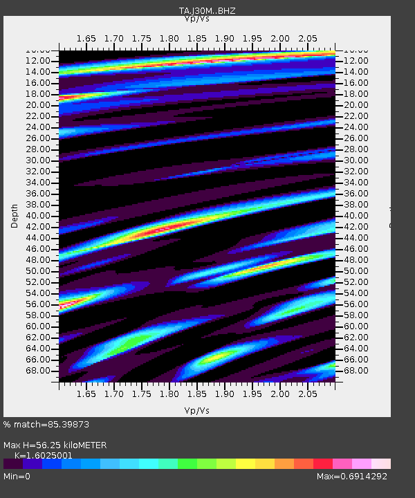
J30M Hart River, Yukon, CAN - Earthquake Result Viewer
| Earthquake location: |
Near Coast Of Oaxaca, Mexico |
| Earthquake latitude/longitude: |
15.6/-95.9 |
| Earthquake time(UTC): |
2020/07/24 (206) 03:19:51 GMT |
| Earthquake Depth: |
6.6 km |
| Earthquake Magnitude: |
5.5 mww |
| Earthquake Catalog/Contributor: |
NEIC PDE/us |
|
| Network: |
TA USArray Transportable Network (new EarthScope stations) |
| Station: |
J30M Hart River, Yukon, CAN |
| Lat/Lon: |
64.58 N/136.33 W |
| Elevation: |
1419 m |
|
| Distance: |
56.1 deg |
| Az: |
340.279 deg |
| Baz: |
131.133 deg |
| Ray Param: |
0.06438943 |
| Estimated Moho Depth: |
56.25 km |
| Estimated Crust Vp/Vs: |
1.60 |
| Assumed Crust Vp: |
6.566 km/s |
| Estimated Crust Vs: |
4.097 km/s |
| Estimated Crust Poisson's Ratio: |
0.18 |
|
| Radial Match: |
85.39873 % |
| Radial Bump: |
394 |
| Transverse Match: |
77.960205 % |
| Transverse Bump: |
400 |
| SOD ConfigId: |
21709731 |
| Insert Time: |
2020-08-07 03:38:25.349 +0000 |
| GWidth: |
2.5 |
| Max Bumps: |
400 |
| Tol: |
0.001 |
|

Signal To Noise
| Channel | StoN | STA | LTA |
| TA:J30M: :BHZ:20200724T03:28:59.775019Z | 8.685871 | 4.4774276E-7 | 5.15484E-8 |
| TA:J30M: :BHN:20200724T03:28:59.775019Z | 3.7348182 | 1.10747614E-7 | 2.9652744E-8 |
| TA:J30M: :BHE:20200724T03:28:59.775019Z | 5.370925 | 2.024265E-7 | 3.7689322E-8 |
| Arrivals |
| Ps | 5.5 SECOND |
| PpPs | 21 SECOND |
| PsPs/PpSs | 26 SECOND |


