You are here: Home > Network List > TA - USArray Transportable Network (new EarthScope stations) Stations List
> Station M16K Timber Creek, AK, USA > Earthquake Result Viewer
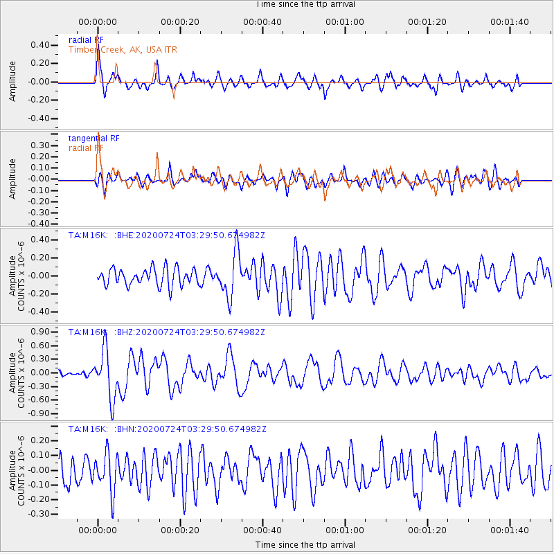
M16K Timber Creek, AK, USA - Earthquake Result Viewer
*The percent match for this event was below the threshold and hence no stack was calculated.
| Earthquake location: |
Near Coast Of Oaxaca, Mexico |
| Earthquake latitude/longitude: |
15.6/-95.9 |
| Earthquake time(UTC): |
2020/07/24 (206) 03:19:51 GMT |
| Earthquake Depth: |
6.6 km |
| Earthquake Magnitude: |
5.5 mww |
| Earthquake Catalog/Contributor: |
NEIC PDE/us |
|
| Network: |
TA USArray Transportable Network (new EarthScope stations) |
| Station: |
M16K Timber Creek, AK, USA |
| Lat/Lon: |
61.02 N/158.96 W |
| Elevation: |
394 m |
|
| Distance: |
63.5 deg |
| Az: |
330.978 deg |
| Baz: |
106.274 deg |
| Ray Param: |
$rayparam |
*The percent match for this event was below the threshold and hence was not used in the summary stack. |
|
| Radial Match: |
72.3598 % |
| Radial Bump: |
400 |
| Transverse Match: |
64.89849 % |
| Transverse Bump: |
400 |
| SOD ConfigId: |
21709731 |
| Insert Time: |
2020-08-07 03:38:45.170 +0000 |
| GWidth: |
2.5 |
| Max Bumps: |
400 |
| Tol: |
0.001 |
|
Signal To Noise
| Channel | StoN | STA | LTA |
| TA:M16K: :BHZ:20200724T03:29:50.674982Z | 9.084386 | 5.542147E-7 | 6.100739E-8 |
| TA:M16K: :BHN:20200724T03:29:50.674982Z | 1.4919629 | 1.3744793E-7 | 9.212557E-8 |
| TA:M16K: :BHE:20200724T03:29:50.674982Z | 2.7819068 | 2.5703233E-7 | 9.2394295E-8 |
| Arrivals |
| Ps | |
| PpPs | |
| PsPs/PpSs | |


