You are here: Home > Network List > TA - USArray Transportable Network (new EarthScope stations) Stations List
> Station R33M Jennings River, BC, CAN > Earthquake Result Viewer
R33M Jennings River, BC, CAN - Earthquake Result Viewer

| Earthquake location: |
Near Coast Of Oaxaca, Mexico |
| Earthquake latitude/longitude: |
15.6/-95.9 |
| Earthquake time(UTC): |
2020/07/24 (206) 03:19:51 GMT |
| Earthquake Depth: |
6.6 km |
| Earthquake Magnitude: |
5.5 mww |
| Earthquake Catalog/Contributor: |
NEIC PDE/us |
|
| Network: |
TA USArray Transportable Network (new EarthScope stations) |
| Station: |
R33M Jennings River, BC, CAN |
| Lat/Lon: |
59.39 N/130.97 W |
| Elevation: |
1437 m |
|
| Distance: |
50.7 deg |
| Az: |
337.666 deg |
| Baz: |
134.307 deg |
| Ray Param: |
0.06788813 |
| Estimated Moho Depth: |
39.75 km |
| Estimated Crust Vp/Vs: |
1.70 |
| Assumed Crust Vp: |
6.597 km/s |
| Estimated Crust Vs: |
3.875 km/s |
| Estimated Crust Poisson's Ratio: |
0.24 |
|
| Radial Match: |
90.75269 % |
| Radial Bump: |
292 |
| Transverse Match: |
67.55623 % |
| Transverse Bump: |
295 |
| SOD ConfigId: |
21709731 |
| Insert Time: |
2020-08-07 03:39:23.908 +0000 |
| GWidth: |
2.5 |
| Max Bumps: |
400 |
| Tol: |
0.001 |
|
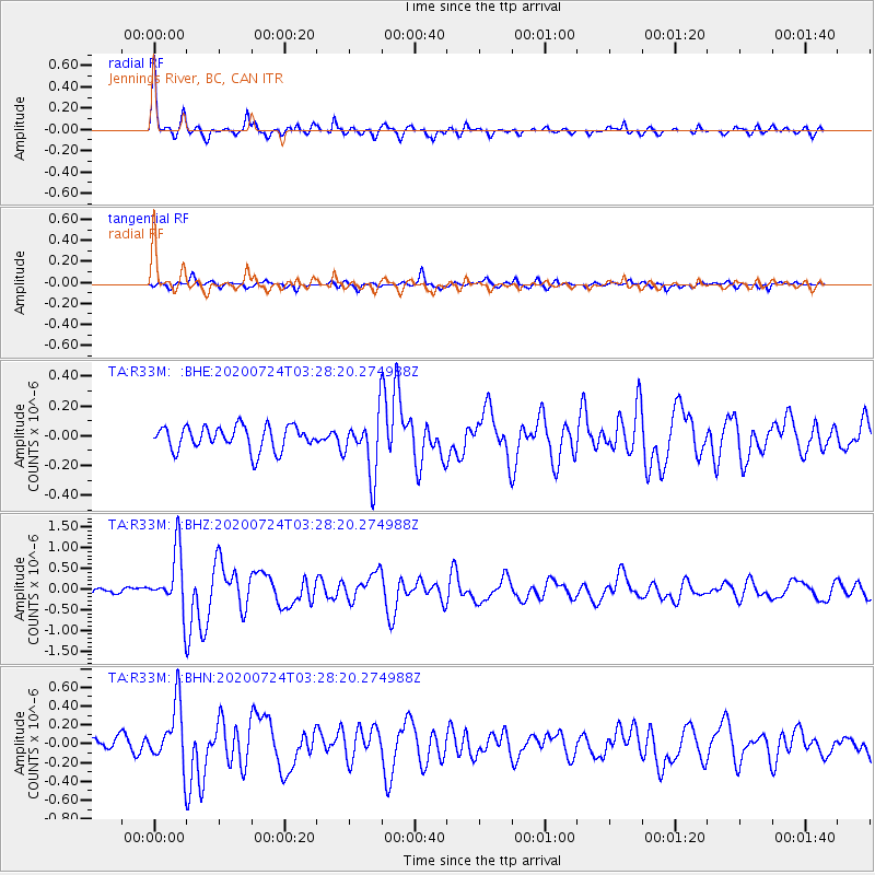
Signal To Noise
| Channel | StoN | STA | LTA |
| TA:R33M: :BHZ:20200724T03:28:20.274988Z | 9.72783 | 7.174427E-7 | 7.3751565E-8 |
| TA:R33M: :BHN:20200724T03:28:20.274988Z | 4.44468 | 3.228414E-7 | 7.263546E-8 |
| TA:R33M: :BHE:20200724T03:28:20.274988Z | 2.4592845 | 1.968884E-7 | 8.0059216E-8 |
| Arrivals |
| Ps | 4.5 SECOND |
| PpPs | 15 SECOND |
| PsPs/PpSs | 20 SECOND |


