You are here: Home > Network List > UO - University of Oregon Regional Network Stations List
> Station RAIN Rainier, OR, USA > Earthquake Result Viewer
RAIN Rainier, OR, USA - Earthquake Result Viewer
| Earthquake location: |
Near Coast Of Oaxaca, Mexico |
| Earthquake latitude/longitude: |
15.6/-95.9 |
| Earthquake time(UTC): |
2020/07/24 (206) 03:19:51 GMT |
| Earthquake Depth: |
6.6 km |
| Earthquake Magnitude: |
5.5 mww |
| Earthquake Catalog/Contributor: |
NEIC PDE/us |
|
| Network: |
UO University of Oregon Regional Network |
| Station: |
RAIN Rainier, OR, USA |
| Lat/Lon: |
46.08 N/123.01 W |
| Elevation: |
236 m |
|
| Distance: |
37.9 deg |
| Az: |
328.9 deg |
| Baz: |
134.352 deg |
| Ray Param: |
0.075880654 |
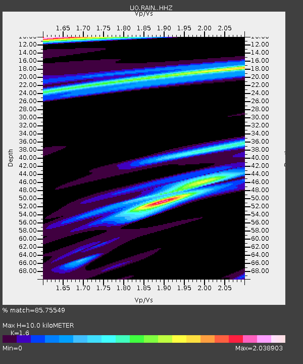
| Estimated Moho Depth: |
10.0 km |
| Estimated Crust Vp/Vs: |
1.60 |
| Assumed Crust Vp: |
6.566 km/s |
| Estimated Crust Vs: |
4.104 km/s |
| Estimated Crust Poisson's Ratio: |
0.18 |
|
| Radial Match: |
85.75549 % |
| Radial Bump: |
361 |
| Transverse Match: |
44.914223 % |
| Transverse Bump: |
400 |
| SOD ConfigId: |
21709731 |
| Insert Time: |
2020-08-07 03:40:15.267 +0000 |
| GWidth: |
2.5 |
| Max Bumps: |
400 |
| Tol: |
0.001 |
|

Signal To Noise
| Channel | StoN | STA | LTA |
| UO:RAIN: :HHZ:20200724T03:26:38.018Z | 5.816264 | 8.959082E-7 | 1.5403499E-7 |
| UO:RAIN: :HHN:20200724T03:26:38.018Z | 1.5027183 | 3.571712E-7 | 2.376834E-7 |
| UO:RAIN: :HHE:20200724T03:26:38.018Z | 1.5621123 | 4.5259148E-7 | 2.8973042E-7 |
| Arrivals |
| Ps | 1.0 SECOND |
| PpPs | 3.6 SECOND |
| PsPs/PpSs | 4.6 SECOND |


