You are here: Home > Network List > US - United States National Seismic Network Stations List
> Station AGMN Agassiz National Wildlife Refuge, Minnesota, USA > Earthquake Result Viewer
AGMN Agassiz National Wildlife Refuge, Minnesota, USA - Earthquake Result Viewer
| Earthquake location: |
Near Coast Of Oaxaca, Mexico |
| Earthquake latitude/longitude: |
15.6/-95.9 |
| Earthquake time(UTC): |
2020/07/24 (206) 03:19:51 GMT |
| Earthquake Depth: |
6.6 km |
| Earthquake Magnitude: |
5.5 mww |
| Earthquake Catalog/Contributor: |
NEIC PDE/us |
|
| Network: |
US United States National Seismic Network |
| Station: |
AGMN Agassiz National Wildlife Refuge, Minnesota, USA |
| Lat/Lon: |
48.30 N/95.86 W |
| Elevation: |
351 m |
|
| Distance: |
32.6 deg |
| Az: |
0.029 deg |
| Baz: |
180.041 deg |
| Ray Param: |
0.07860672 |
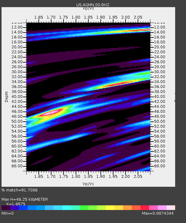
| Estimated Moho Depth: |
46.25 km |
| Estimated Crust Vp/Vs: |
1.70 |
| Assumed Crust Vp: |
6.419 km/s |
| Estimated Crust Vs: |
3.782 km/s |
| Estimated Crust Poisson's Ratio: |
0.23 |
|
| Radial Match: |
91.7086 % |
| Radial Bump: |
400 |
| Transverse Match: |
60.443542 % |
| Transverse Bump: |
400 |
| SOD ConfigId: |
21709731 |
| Insert Time: |
2020-08-07 03:40:35.967 +0000 |
| GWidth: |
2.5 |
| Max Bumps: |
400 |
| Tol: |
0.001 |
|

Signal To Noise
| Channel | StoN | STA | LTA |
| US:AGMN:00:BHZ:20200724T03:25:52.325006Z | 22.078224 | 1.137078E-6 | 5.150224E-8 |
| US:AGMN:00:BH1:20200724T03:25:52.325006Z | 8.291215 | 8.458038E-7 | 1.02012045E-7 |
| US:AGMN:00:BH2:20200724T03:25:52.325006Z | 1.8986135 | 1.680041E-7 | 8.848779E-8 |
| Arrivals |
| Ps | 5.5 SECOND |
| PpPs | 18 SECOND |
| PsPs/PpSs | 23 SECOND |


