You are here: Home > Network List > UW - Pacific Northwest Regional Seismic Network Stations List
> Station MANO Manastash Observatory, WA, USA > Earthquake Result Viewer
MANO Manastash Observatory, WA, USA - Earthquake Result Viewer
| Earthquake location: |
Near Coast Of Oaxaca, Mexico |
| Earthquake latitude/longitude: |
15.6/-95.9 |
| Earthquake time(UTC): |
2020/07/24 (206) 03:19:51 GMT |
| Earthquake Depth: |
6.6 km |
| Earthquake Magnitude: |
5.5 mww |
| Earthquake Catalog/Contributor: |
NEIC PDE/us |
|
| Network: |
UW Pacific Northwest Regional Seismic Network |
| Station: |
MANO Manastash Observatory, WA, USA |
| Lat/Lon: |
46.95 N/120.72 W |
| Elevation: |
1200 m |
|
| Distance: |
37.4 deg |
| Az: |
331.749 deg |
| Baz: |
138.261 deg |
| Ray Param: |
0.07614927 |
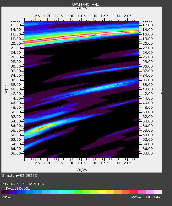
| Estimated Moho Depth: |
15.75 km |
| Estimated Crust Vp/Vs: |
1.91 |
| Assumed Crust Vp: |
6.597 km/s |
| Estimated Crust Vs: |
3.454 km/s |
| Estimated Crust Poisson's Ratio: |
0.31 |
|
| Radial Match: |
82.68273 % |
| Radial Bump: |
347 |
| Transverse Match: |
74.97144 % |
| Transverse Bump: |
400 |
| SOD ConfigId: |
21709731 |
| Insert Time: |
2020-08-07 03:41:50.757 +0000 |
| GWidth: |
2.5 |
| Max Bumps: |
400 |
| Tol: |
0.001 |
|

Signal To Noise
| Channel | StoN | STA | LTA |
| UW:MANO: :HHZ:20200724T03:26:34.11001Z | 13.18226 | 1.7482265E-6 | 1.3261965E-7 |
| UW:MANO: :HHN:20200724T03:26:34.11001Z | 3.6758282 | 4.1356583E-7 | 1.1250956E-7 |
| UW:MANO: :HHE:20200724T03:26:34.11001Z | 2.1222215 | 2.692761E-7 | 1.2688406E-7 |
| Arrivals |
| Ps | 2.3 SECOND |
| PpPs | 6.5 SECOND |
| PsPs/PpSs | 8.8 SECOND |


