You are here: Home > Network List > WY - Yellowstone Wyoming Seismic Network Stations List
> Station YDD Grant Village, YNP, WY, USA old TA-H17A > Earthquake Result Viewer
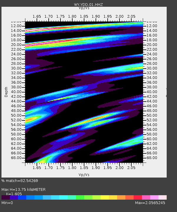
YDD Grant Village, YNP, WY, USA old TA-H17A - Earthquake Result Viewer
| Earthquake location: |
Near Coast Of Oaxaca, Mexico |
| Earthquake latitude/longitude: |
15.6/-95.9 |
| Earthquake time(UTC): |
2020/07/24 (206) 03:19:51 GMT |
| Earthquake Depth: |
6.6 km |
| Earthquake Magnitude: |
5.5 mww |
| Earthquake Catalog/Contributor: |
NEIC PDE/us |
|
| Network: |
WY Yellowstone Wyoming Seismic Network |
| Station: |
YDD Grant Village, YNP, WY, USA old TA-H17A |
| Lat/Lon: |
44.40 N/110.58 W |
| Elevation: |
2400 m |
|
| Distance: |
31.3 deg |
| Az: |
339.498 deg |
| Baz: |
151.918 deg |
| Ray Param: |
0.079144135 |
| Estimated Moho Depth: |
13.75 km |
| Estimated Crust Vp/Vs: |
1.61 |
| Assumed Crust Vp: |
6.35 km/s |
| Estimated Crust Vs: |
3.956 km/s |
| Estimated Crust Poisson's Ratio: |
0.18 |
|
| Radial Match: |
82.54269 % |
| Radial Bump: |
400 |
| Transverse Match: |
74.34049 % |
| Transverse Bump: |
400 |
| SOD ConfigId: |
21709731 |
| Insert Time: |
2020-08-07 03:43:17.326 +0000 |
| GWidth: |
2.5 |
| Max Bumps: |
400 |
| Tol: |
0.001 |
|

Signal To Noise
| Channel | StoN | STA | LTA |
| WY:YDD:01:HHZ:20200724T03:25:40.809992Z | 7.9736323 | 1.7086622E-8 | 2.1428905E-9 |
| WY:YDD:01:HHN:20200724T03:25:40.809992Z | 10.648443 | 1.5950631E-8 | 1.4979309E-9 |
| WY:YDD:01:HHE:20200724T03:25:40.809992Z | 4.076657 | 9.602656E-9 | 2.3555222E-9 |
| Arrivals |
| Ps | 1.4 SECOND |
| PpPs | 5.2 SECOND |
| PsPs/PpSs | 6.6 SECOND |


