You are here: Home > Network List > GT - Global Telemetered Seismograph Network (USAF/USGS) Stations List
> Station LPAZ La Paz , Bolivia > Earthquake Result Viewer
LPAZ La Paz , Bolivia - Earthquake Result Viewer

| Earthquake location: |
South Sandwich Islands Region |
| Earthquake latitude/longitude: |
-60.8/-25.3 |
| Earthquake time(UTC): |
2020/07/26 (208) 00:53:59 GMT |
| Earthquake Depth: |
10 km |
| Earthquake Magnitude: |
6.3 mww |
| Earthquake Catalog/Contributor: |
NEIC PDE/us |
|
| Network: |
GT Global Telemetered Seismograph Network (USAF/USGS) |
| Station: |
LPAZ La Paz , Bolivia |
| Lat/Lon: |
16.17 S/68.08 W |
| Elevation: |
4817 m |
|
| Distance: |
54.0 deg |
| Az: |
306.28 deg |
| Baz: |
155.695 deg |
| Ray Param: |
0.065701455 |
| Estimated Moho Depth: |
53.75 km |
| Estimated Crust Vp/Vs: |
1.73 |
| Assumed Crust Vp: |
6.454 km/s |
| Estimated Crust Vs: |
3.725 km/s |
| Estimated Crust Poisson's Ratio: |
0.25 |
|
| Radial Match: |
88.84753 % |
| Radial Bump: |
400 |
| Transverse Match: |
83.38417 % |
| Transverse Bump: |
400 |
| SOD ConfigId: |
21709731 |
| Insert Time: |
2020-08-09 00:57:38.829 +0000 |
| GWidth: |
2.5 |
| Max Bumps: |
400 |
| Tol: |
0.001 |
|
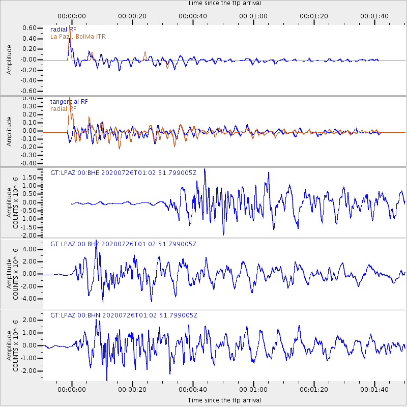
Signal To Noise
| Channel | StoN | STA | LTA |
| GT:LPAZ:00:BHZ:20200726T01:02:51.799005Z | 20.765455 | 1.2116435E-6 | 5.8349002E-8 |
| GT:LPAZ:00:BHN:20200726T01:02:51.799005Z | 7.471612 | 4.3017704E-7 | 5.7574866E-8 |
| GT:LPAZ:00:BHE:20200726T01:02:51.799005Z | 5.789046 | 2.7907524E-7 | 4.820747E-8 |
| Arrivals |
| Ps | 6.4 SECOND |
| PpPs | 22 SECOND |
| PsPs/PpSs | 28 SECOND |


