You are here: Home > Network List > AV - Alaska Volcano Observatory Stations List
> Station AMKA Regional Station, Amchitka Island, Alaska > Earthquake Result Viewer
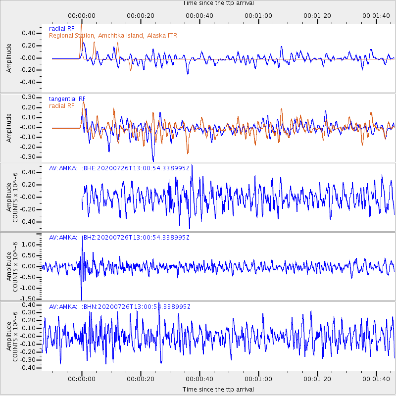
AMKA Regional Station, Amchitka Island, Alaska - Earthquake Result Viewer
*The percent match for this event was below the threshold and hence no stack was calculated.
| Earthquake location: |
Taiwan Region |
| Earthquake latitude/longitude: |
24.3/122.5 |
| Earthquake time(UTC): |
2020/07/26 (208) 12:52:29 GMT |
| Earthquake Depth: |
53 km |
| Earthquake Magnitude: |
5.2 Mww |
| Earthquake Catalog/Contributor: |
NEIC PDE/us |
|
| Network: |
AV Alaska Volcano Observatory |
| Station: |
AMKA Regional Station, Amchitka Island, Alaska |
| Lat/Lon: |
51.38 N/179.30 E |
| Elevation: |
116 m |
|
| Distance: |
50.9 deg |
| Az: |
42.575 deg |
| Baz: |
260.14 deg |
| Ray Param: |
$rayparam |
*The percent match for this event was below the threshold and hence was not used in the summary stack. |
|
| Radial Match: |
42.785606 % |
| Radial Bump: |
400 |
| Transverse Match: |
57.67563 % |
| Transverse Bump: |
400 |
| SOD ConfigId: |
21709731 |
| Insert Time: |
2020-08-09 12:55:49.862 +0000 |
| GWidth: |
2.5 |
| Max Bumps: |
400 |
| Tol: |
0.001 |
|
Signal To Noise
| Channel | StoN | STA | LTA |
| AV:AMKA: :BHZ:20200726T13:00:54.338995Z | 3.1596248 | 4.5847045E-7 | 1.4510282E-7 |
| AV:AMKA: :BHN:20200726T13:00:54.338995Z | 1.1949775 | 1.3445784E-7 | 1.1251913E-7 |
| AV:AMKA: :BHE:20200726T13:00:54.338995Z | 1.2689048 | 1.7534315E-7 | 1.3818463E-7 |
| Arrivals |
| Ps | |
| PpPs | |
| PsPs/PpSs | |


