You are here: Home > Network List > CC - Cascade Chain Volcano Monitoring Stations List
> Station OBSR Observation Rock, Mt. Rainier, WA > Earthquake Result Viewer
OBSR Observation Rock, Mt. Rainier, WA - Earthquake Result Viewer
| Earthquake location: |
Taiwan Region |
| Earthquake latitude/longitude: |
24.3/122.5 |
| Earthquake time(UTC): |
2020/07/26 (208) 12:52:29 GMT |
| Earthquake Depth: |
53 km |
| Earthquake Magnitude: |
5.2 Mww |
| Earthquake Catalog/Contributor: |
NEIC PDE/us |
|
| Network: |
CC Cascade Chain Volcano Monitoring |
| Station: |
OBSR Observation Rock, Mt. Rainier, WA |
| Lat/Lon: |
46.90 N/121.82 W |
| Elevation: |
2382 m |
|
| Distance: |
88.5 deg |
| Az: |
38.166 deg |
| Baz: |
304.668 deg |
| Ray Param: |
0.042435013 |
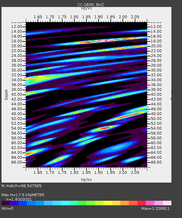
| Estimated Moho Depth: |
17.5 km |
| Estimated Crust Vp/Vs: |
1.93 |
| Assumed Crust Vp: |
6.597 km/s |
| Estimated Crust Vs: |
3.418 km/s |
| Estimated Crust Poisson's Ratio: |
0.32 |
|
| Radial Match: |
86.547585 % |
| Radial Bump: |
400 |
| Transverse Match: |
86.26441 % |
| Transverse Bump: |
400 |
| SOD ConfigId: |
21709731 |
| Insert Time: |
2020-08-09 12:57:48.282 +0000 |
| GWidth: |
2.5 |
| Max Bumps: |
400 |
| Tol: |
0.001 |
|

Signal To Noise
| Channel | StoN | STA | LTA |
| CC:OBSR: :BHZ:20200726T13:04:45.145025Z | 15.102863 | 1.537885E-6 | 1.0182738E-7 |
| CC:OBSR: :BHN:20200726T13:04:45.145025Z | 19.144154 | 1.8792924E-6 | 9.816534E-8 |
| CC:OBSR: :BHE:20200726T13:04:45.145025Z | 8.435029 | 1.2118818E-6 | 1.4367252E-7 |
| Arrivals |
| Ps | 2.5 SECOND |
| PpPs | 7.6 SECOND |
| PsPs/PpSs | 10 SECOND |


