You are here: Home > Network List > CN - Canadian National Seismograph Network Stations List
> Station INK INUVIK, NT > Earthquake Result Viewer
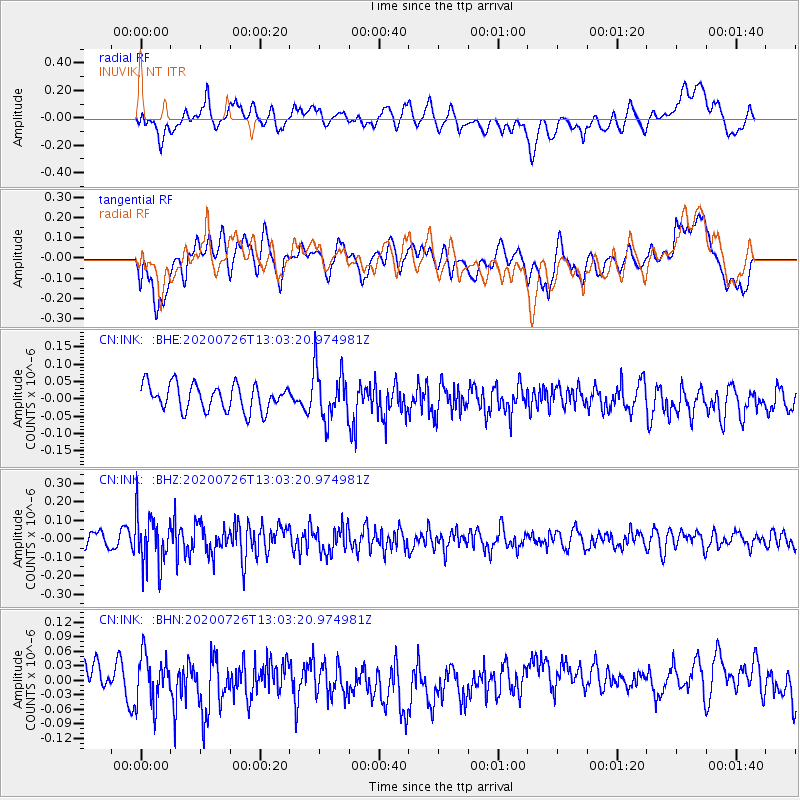
INK INUVIK, NT - Earthquake Result Viewer
*The percent match for this event was below the threshold and hence no stack was calculated.
| Earthquake location: |
Taiwan Region |
| Earthquake latitude/longitude: |
24.3/122.5 |
| Earthquake time(UTC): |
2020/07/26 (208) 12:52:29 GMT |
| Earthquake Depth: |
53 km |
| Earthquake Magnitude: |
5.2 Mww |
| Earthquake Catalog/Contributor: |
NEIC PDE/us |
|
| Network: |
CN Canadian National Seismograph Network |
| Station: |
INK INUVIK, NT |
| Lat/Lon: |
68.31 N/133.53 W |
| Elevation: |
44 m |
|
| Distance: |
72.7 deg |
| Az: |
22.197 deg |
| Baz: |
291.968 deg |
| Ray Param: |
$rayparam |
*The percent match for this event was below the threshold and hence was not used in the summary stack. |
|
| Radial Match: |
47.563107 % |
| Radial Bump: |
400 |
| Transverse Match: |
53.99351 % |
| Transverse Bump: |
400 |
| SOD ConfigId: |
21709731 |
| Insert Time: |
2020-08-09 12:59:17.993 +0000 |
| GWidth: |
2.5 |
| Max Bumps: |
400 |
| Tol: |
0.001 |
|
Signal To Noise
| Channel | StoN | STA | LTA |
| CN:INK: :BHZ:20200726T13:03:20.974981Z | 2.834959 | 1.3768157E-7 | 4.8565628E-8 |
| CN:INK: :BHN:20200726T13:03:20.974981Z | 1.3397504 | 5.160024E-8 | 3.8514816E-8 |
| CN:INK: :BHE:20200726T13:03:20.974981Z | 2.0023003 | 7.558877E-8 | 3.7750972E-8 |
| Arrivals |
| Ps | |
| PpPs | |
| PsPs/PpSs | |


