You are here: Home > Network List > US - United States National Seismic Network Stations List
> Station LKWY Lake (Yellowstone--Lake), Wyoming, USA > Earthquake Result Viewer
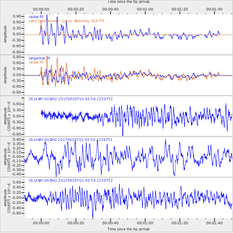
LKWY Lake (Yellowstone--Lake), Wyoming, USA - Earthquake Result Viewer
*The percent match for this event was below the threshold and hence no stack was calculated.
| Earthquake location: |
Northern Mid-Atlantic Ridge |
| Earthquake latitude/longitude: |
33.7/-38.5 |
| Earthquake time(UTC): |
2017/06/30 (181) 01:34:58 GMT |
| Earthquake Depth: |
10 km |
| Earthquake Magnitude: |
5.8 Mwb |
| Earthquake Catalog/Contributor: |
NEIC PDE/us |
|
| Network: |
US United States National Seismic Network |
| Station: |
LKWY Lake (Yellowstone--Lake), Wyoming, USA |
| Lat/Lon: |
44.57 N/110.40 W |
| Elevation: |
2424 m |
|
| Distance: |
55.1 deg |
| Az: |
304.082 deg |
| Baz: |
74.89 deg |
| Ray Param: |
$rayparam |
*The percent match for this event was below the threshold and hence was not used in the summary stack. |
|
| Radial Match: |
70.35705 % |
| Radial Bump: |
400 |
| Transverse Match: |
67.613846 % |
| Transverse Bump: |
400 |
| SOD ConfigId: |
2140511 |
| Insert Time: |
2017-07-27 23:35:45.682 +0000 |
| GWidth: |
2.5 |
| Max Bumps: |
400 |
| Tol: |
0.001 |
|
Signal To Noise
| Channel | StoN | STA | LTA |
| US:LKWY:00:BHZ:20170630T01:43:59.223975Z | 3.19218 | 1.7099939E-7 | 5.3568215E-8 |
| US:LKWY:00:BH1:20170630T01:43:59.223975Z | 0.96056324 | 8.588102E-8 | 8.940694E-8 |
| US:LKWY:00:BH2:20170630T01:43:59.223975Z | 1.1161598 | 1.2924181E-7 | 1.15791494E-7 |
| Arrivals |
| Ps | |
| PpPs | |
| PsPs/PpSs | |


