You are here: Home > Network List > US - United States National Seismic Network Stations List
> Station MSO Missoula, Montana, USA > Earthquake Result Viewer
MSO Missoula, Montana, USA - Earthquake Result Viewer
*The percent match for this event was below the threshold and hence no stack was calculated.
| Earthquake location: |
Northern Mid-Atlantic Ridge |
| Earthquake latitude/longitude: |
33.7/-38.5 |
| Earthquake time(UTC): |
2017/06/30 (181) 01:34:58 GMT |
| Earthquake Depth: |
10 km |
| Earthquake Magnitude: |
5.8 Mwb |
| Earthquake Catalog/Contributor: |
NEIC PDE/us |
|
| Network: |
US United States National Seismic Network |
| Station: |
MSO Missoula, Montana, USA |
| Lat/Lon: |
46.83 N/113.94 W |
| Elevation: |
1264 m |
|
| Distance: |
56.9 deg |
| Az: |
307.509 deg |
| Baz: |
74.282 deg |
| Ray Param: |
$rayparam |
*The percent match for this event was below the threshold and hence was not used in the summary stack. |
|
| Radial Match: |
61.809544 % |
| Radial Bump: |
400 |
| Transverse Match: |
57.86465 % |
| Transverse Bump: |
400 |
| SOD ConfigId: |
2140511 |
| Insert Time: |
2017-07-27 23:35:49.223 +0000 |
| GWidth: |
2.5 |
| Max Bumps: |
400 |
| Tol: |
0.001 |
|
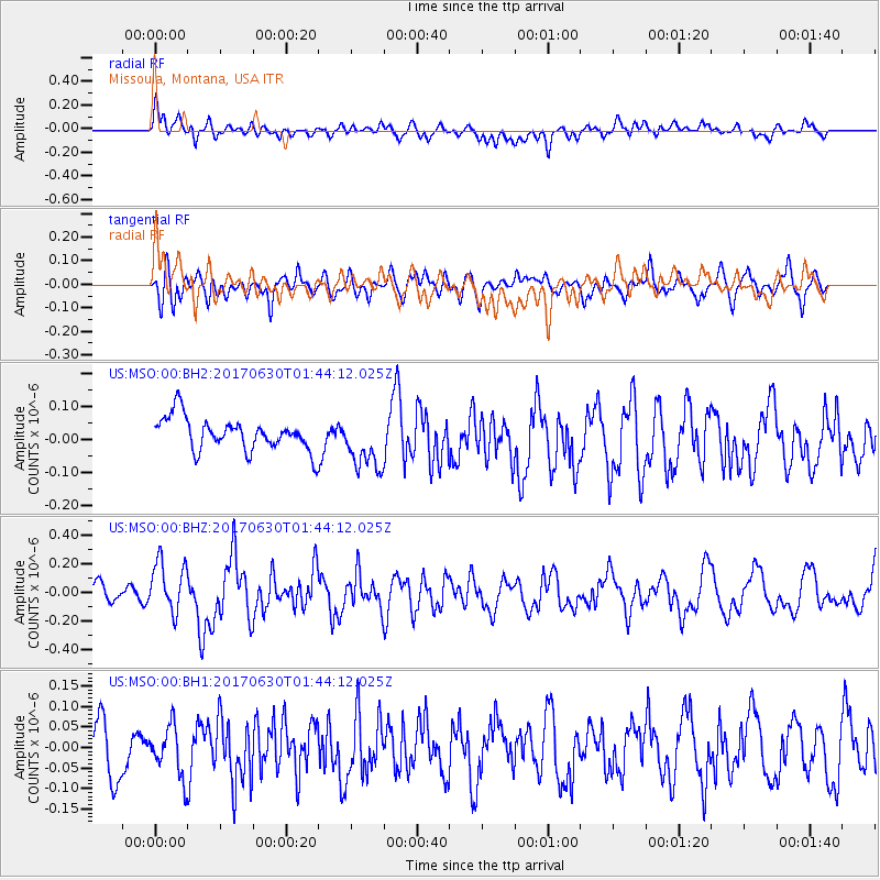
Signal To Noise
| Channel | StoN | STA | LTA |
| US:MSO:00:BHZ:20170630T01:44:12.025Z | 3.560043 | 1.7820044E-7 | 5.0055696E-8 |
| US:MSO:00:BH1:20170630T01:44:12.025Z | 1.0598959 | 6.127963E-8 | 5.7816653E-8 |
| US:MSO:00:BH2:20170630T01:44:12.025Z | 1.6767449 | 8.2177216E-8 | 4.900997E-8 |
| Arrivals |
| Ps | |
| PpPs | |
| PsPs/PpSs | |


