You are here: Home > Network List > TA - USArray Transportable Network (new EarthScope stations) Stations List
> Station E18K Tukpahlearik Creek, AK, USA > Earthquake Result Viewer
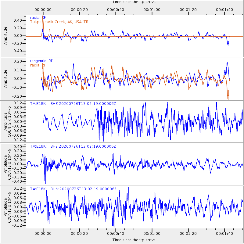
E18K Tukpahlearik Creek, AK, USA - Earthquake Result Viewer
*The percent match for this event was below the threshold and hence no stack was calculated.
| Earthquake location: |
Taiwan Region |
| Earthquake latitude/longitude: |
24.3/122.5 |
| Earthquake time(UTC): |
2020/07/26 (208) 12:52:29 GMT |
| Earthquake Depth: |
53 km |
| Earthquake Magnitude: |
5.2 Mww |
| Earthquake Catalog/Contributor: |
NEIC PDE/us |
|
| Network: |
TA USArray Transportable Network (new EarthScope stations) |
| Station: |
E18K Tukpahlearik Creek, AK, USA |
| Lat/Lon: |
67.42 N/160.60 W |
| Elevation: |
297 m |
|
| Distance: |
62.8 deg |
| Az: |
25.013 deg |
| Baz: |
267.913 deg |
| Ray Param: |
$rayparam |
*The percent match for this event was below the threshold and hence was not used in the summary stack. |
|
| Radial Match: |
58.924713 % |
| Radial Bump: |
400 |
| Transverse Match: |
60.030178 % |
| Transverse Bump: |
400 |
| SOD ConfigId: |
21709731 |
| Insert Time: |
2020-08-09 13:05:53.660 +0000 |
| GWidth: |
2.5 |
| Max Bumps: |
400 |
| Tol: |
0.001 |
|
Signal To Noise
| Channel | StoN | STA | LTA |
| TA:E18K: :BHZ:20200726T13:02:19.000006Z | 3.7731893 | 1.5724115E-7 | 4.167327E-8 |
| TA:E18K: :BHN:20200726T13:02:19.000006Z | 1.3826663 | 4.3115556E-8 | 3.118291E-8 |
| TA:E18K: :BHE:20200726T13:02:19.000006Z | 2.17934 | 6.51179E-8 | 2.9879644E-8 |
| Arrivals |
| Ps | |
| PpPs | |
| PsPs/PpSs | |


