You are here: Home > Network List > TA - USArray Transportable Network (new EarthScope stations) Stations List
> Station F26K Sheenjek River, AK, USA > Earthquake Result Viewer
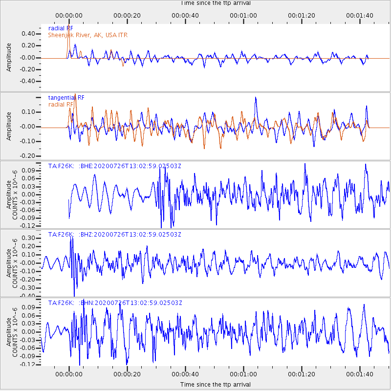
F26K Sheenjek River, AK, USA - Earthquake Result Viewer
*The percent match for this event was below the threshold and hence no stack was calculated.
| Earthquake location: |
Taiwan Region |
| Earthquake latitude/longitude: |
24.3/122.5 |
| Earthquake time(UTC): |
2020/07/26 (208) 12:52:29 GMT |
| Earthquake Depth: |
53 km |
| Earthquake Magnitude: |
5.2 Mww |
| Earthquake Catalog/Contributor: |
NEIC PDE/us |
|
| Network: |
TA USArray Transportable Network (new EarthScope stations) |
| Station: |
F26K Sheenjek River, AK, USA |
| Lat/Lon: |
67.69 N/144.15 W |
| Elevation: |
683 m |
|
| Distance: |
69.1 deg |
| Az: |
24.077 deg |
| Baz: |
282.742 deg |
| Ray Param: |
$rayparam |
*The percent match for this event was below the threshold and hence was not used in the summary stack. |
|
| Radial Match: |
58.57291 % |
| Radial Bump: |
400 |
| Transverse Match: |
40.119747 % |
| Transverse Bump: |
400 |
| SOD ConfigId: |
21709731 |
| Insert Time: |
2020-08-09 13:06:22.932 +0000 |
| GWidth: |
2.5 |
| Max Bumps: |
400 |
| Tol: |
0.001 |
|
Signal To Noise
| Channel | StoN | STA | LTA |
| TA:F26K: :BHZ:20200726T13:02:59.02503Z | 3.6528943 | 1.5306672E-7 | 4.1902858E-8 |
| TA:F26K: :BHN:20200726T13:02:59.02503Z | 1.1195217 | 4.342899E-8 | 3.8792447E-8 |
| TA:F26K: :BHE:20200726T13:02:59.02503Z | 1.6456792 | 5.4645643E-8 | 3.3205527E-8 |
| Arrivals |
| Ps | |
| PpPs | |
| PsPs/PpSs | |


