You are here: Home > Network List > US - United States National Seismic Network Stations List
> Station HAWA Hanford, Washington, USA > Earthquake Result Viewer
HAWA Hanford, Washington, USA - Earthquake Result Viewer
*The percent match for this event was below the threshold and hence no stack was calculated.
| Earthquake location: |
Taiwan Region |
| Earthquake latitude/longitude: |
24.3/122.5 |
| Earthquake time(UTC): |
2020/07/26 (208) 12:52:29 GMT |
| Earthquake Depth: |
53 km |
| Earthquake Magnitude: |
5.2 Mww |
| Earthquake Catalog/Contributor: |
NEIC PDE/us |
|
| Network: |
US United States National Seismic Network |
| Station: |
HAWA Hanford, Washington, USA |
| Lat/Lon: |
46.39 N/119.53 W |
| Elevation: |
364 m |
|
| Distance: |
90.1 deg |
| Az: |
37.666 deg |
| Baz: |
306.316 deg |
| Ray Param: |
$rayparam |
*The percent match for this event was below the threshold and hence was not used in the summary stack. |
|
| Radial Match: |
54.5876 % |
| Radial Bump: |
400 |
| Transverse Match: |
52.646267 % |
| Transverse Bump: |
400 |
| SOD ConfigId: |
21709731 |
| Insert Time: |
2020-08-09 13:08:35.671 +0000 |
| GWidth: |
2.5 |
| Max Bumps: |
400 |
| Tol: |
0.001 |
|
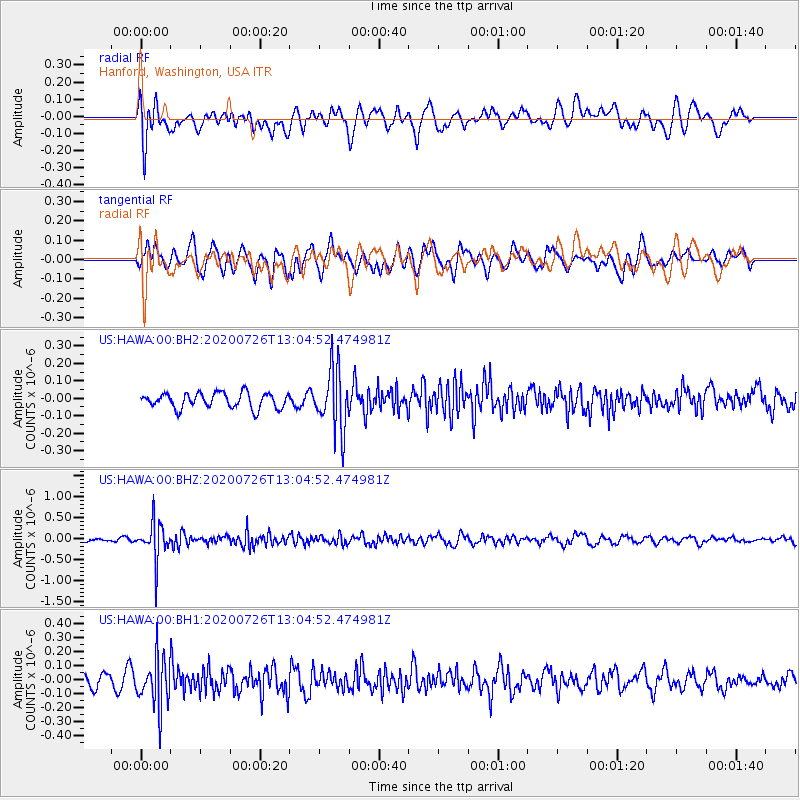
Signal To Noise
| Channel | StoN | STA | LTA |
| US:HAWA:00:BHZ:20200726T13:04:52.474981Z | 5.9052806 | 4.50507E-7 | 7.628884E-8 |
| US:HAWA:00:BH1:20200726T13:04:52.474981Z | 3.4205232 | 1.7265205E-7 | 5.0475336E-8 |
| US:HAWA:00:BH2:20200726T13:04:52.474981Z | 4.0617623 | 1.7709579E-7 | 4.3600725E-8 |
| Arrivals |
| Ps | |
| PpPs | |
| PsPs/PpSs | |


