You are here: Home > Network List > AT - Alaska Tsunami Warning Seismic System Stations List
> Station SDPT Sand Point, Alaska > Earthquake Result Viewer
SDPT Sand Point, Alaska - Earthquake Result Viewer
| Earthquake location: |
Mindanao, Philippines |
| Earthquake latitude/longitude: |
9.0/126.3 |
| Earthquake time(UTC): |
2020/07/27 (209) 17:32:44 GMT |
| Earthquake Depth: |
39 km |
| Earthquake Magnitude: |
5.7 Mww |
| Earthquake Catalog/Contributor: |
NEIC PDE/us |
|
| Network: |
AT Alaska Tsunami Warning Seismic System |
| Station: |
SDPT Sand Point, Alaska |
| Lat/Lon: |
55.35 N/160.48 W |
| Elevation: |
74 m |
|
| Distance: |
73.1 deg |
| Az: |
34.86 deg |
| Baz: |
261.305 deg |
| Ray Param: |
0.053155947 |
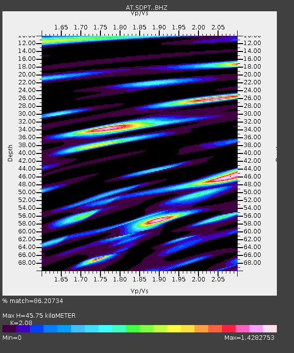
| Estimated Moho Depth: |
45.75 km |
| Estimated Crust Vp/Vs: |
2.08 |
| Assumed Crust Vp: |
5.989 km/s |
| Estimated Crust Vs: |
2.879 km/s |
| Estimated Crust Poisson's Ratio: |
0.35 |
|
| Radial Match: |
86.20734 % |
| Radial Bump: |
400 |
| Transverse Match: |
80.51569 % |
| Transverse Bump: |
400 |
| SOD ConfigId: |
21709731 |
| Insert Time: |
2020-08-10 17:36:34.230 +0000 |
| GWidth: |
2.5 |
| Max Bumps: |
400 |
| Tol: |
0.001 |
|

Signal To Noise
| Channel | StoN | STA | LTA |
| AT:SDPT: :BHZ:20200727T17:43:40.219998Z | 34.53842 | 3.8844855E-6 | 1.12468534E-7 |
| AT:SDPT: :BHN:20200727T17:43:40.219998Z | 12.439335 | 1.451818E-6 | 1.1671187E-7 |
| AT:SDPT: :BHE:20200727T17:43:40.219998Z | 13.552484 | 1.7458311E-6 | 1.2882002E-7 |
| Arrivals |
| Ps | 8.5 SECOND |
| PpPs | 23 SECOND |
| PsPs/PpSs | 31 SECOND |


