You are here: Home > Network List > AV - Alaska Volcano Observatory Stations List
> Station KAHG Katmai Hook Glacier, Alaska > Earthquake Result Viewer
KAHG Katmai Hook Glacier, Alaska - Earthquake Result Viewer
| Earthquake location: |
Mindanao, Philippines |
| Earthquake latitude/longitude: |
9.0/126.3 |
| Earthquake time(UTC): |
2020/07/27 (209) 17:32:44 GMT |
| Earthquake Depth: |
39 km |
| Earthquake Magnitude: |
5.7 Mww |
| Earthquake Catalog/Contributor: |
NEIC PDE/us |
|
| Network: |
AV Alaska Volcano Observatory |
| Station: |
KAHG Katmai Hook Glacier, Alaska |
| Lat/Lon: |
58.49 N/154.55 W |
| Elevation: |
923 m |
|
| Distance: |
76.7 deg |
| Az: |
32.007 deg |
| Baz: |
265.522 deg |
| Ray Param: |
0.050756857 |
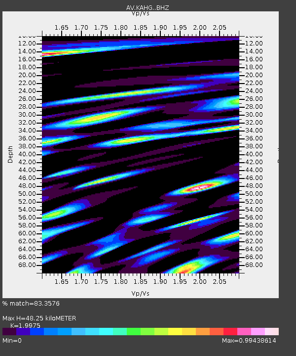
| Estimated Moho Depth: |
48.25 km |
| Estimated Crust Vp/Vs: |
2.00 |
| Assumed Crust Vp: |
6.438 km/s |
| Estimated Crust Vs: |
3.223 km/s |
| Estimated Crust Poisson's Ratio: |
0.33 |
|
| Radial Match: |
83.3576 % |
| Radial Bump: |
400 |
| Transverse Match: |
83.47848 % |
| Transverse Bump: |
400 |
| SOD ConfigId: |
21709731 |
| Insert Time: |
2020-08-10 17:38:01.441 +0000 |
| GWidth: |
2.5 |
| Max Bumps: |
400 |
| Tol: |
0.001 |
|

Signal To Noise
| Channel | StoN | STA | LTA |
| AV:KAHG: :BHZ:20200727T17:44:00.89999Z | 36.958454 | 1.7487141E-6 | 4.7315673E-8 |
| AV:KAHG: :BHN:20200727T17:44:00.89999Z | 14.62295 | 6.230463E-7 | 4.260743E-8 |
| AV:KAHG: :BHE:20200727T17:44:00.89999Z | 10.3828945 | 7.208612E-7 | 6.942776E-8 |
| Arrivals |
| Ps | 7.7 SECOND |
| PpPs | 22 SECOND |
| PsPs/PpSs | 30 SECOND |


