You are here: Home > Network List > TA - USArray Transportable Network (new EarthScope stations) Stations List
> Station F31M Tsiigehtchic, NWT, CAN > Earthquake Result Viewer
F31M Tsiigehtchic, NWT, CAN - Earthquake Result Viewer
| Earthquake location: |
Mindanao, Philippines |
| Earthquake latitude/longitude: |
9.0/126.3 |
| Earthquake time(UTC): |
2020/07/27 (209) 17:32:44 GMT |
| Earthquake Depth: |
39 km |
| Earthquake Magnitude: |
5.7 Mww |
| Earthquake Catalog/Contributor: |
NEIC PDE/us |
|
| Network: |
TA USArray Transportable Network (new EarthScope stations) |
| Station: |
F31M Tsiigehtchic, NWT, CAN |
| Lat/Lon: |
67.44 N/133.74 W |
| Elevation: |
56 m |
|
| Distance: |
85.5 deg |
| Az: |
22.404 deg |
| Baz: |
282.64 deg |
| Ray Param: |
0.044630468 |
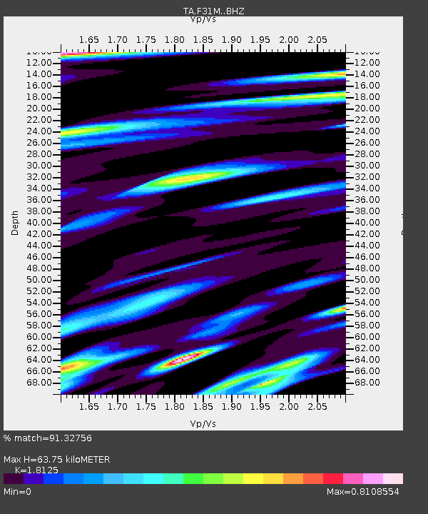
| Estimated Moho Depth: |
63.75 km |
| Estimated Crust Vp/Vs: |
1.81 |
| Assumed Crust Vp: |
6.171 km/s |
| Estimated Crust Vs: |
3.405 km/s |
| Estimated Crust Poisson's Ratio: |
0.28 |
|
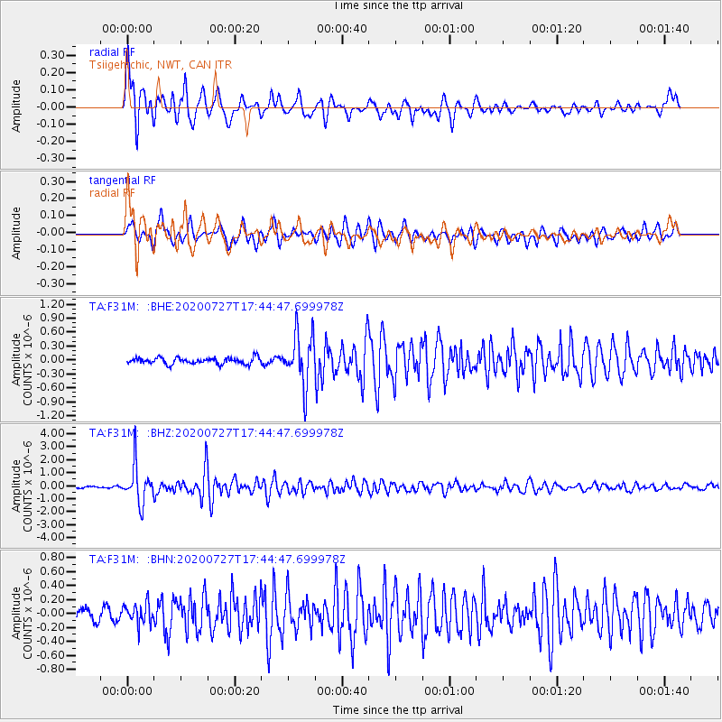
| Radial Match: |
91.32756 % |
| Radial Bump: |
400 |
| Transverse Match: |
85.46655 % |
| Transverse Bump: |
400 |
| SOD ConfigId: |
21709731 |
| Insert Time: |
2020-08-10 17:46:44.150 +0000 |
| GWidth: |
2.5 |
| Max Bumps: |
400 |
| Tol: |
0.001 |
|
Signal To Noise
| Channel | StoN | STA | LTA |
| TA:F31M: :BHZ:20200727T17:44:47.699978Z | 19.658182 | 1.4275207E-6 | 7.2617134E-8 |
| TA:F31M: :BHN:20200727T17:44:47.699978Z | 1.7171069 | 1.5096258E-7 | 8.7916824E-8 |
| TA:F31M: :BHE:20200727T17:44:47.699978Z | 7.9973536 | 5.5211103E-7 | 6.9036716E-8 |
| Arrivals |
| Ps | 8.6 SECOND |
| PpPs | 28 SECOND |
| PsPs/PpSs | 37 SECOND |


