You are here: Home > Network List > TA - USArray Transportable Network (new EarthScope stations) Stations List
> Station G31M Satah River, YT, CAN > Earthquake Result Viewer
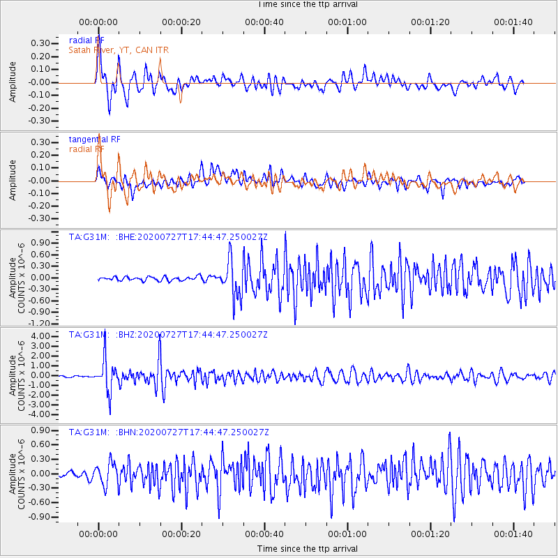
G31M Satah River, YT, CAN - Earthquake Result Viewer
*The percent match for this event was below the threshold and hence no stack was calculated.
| Earthquake location: |
Mindanao, Philippines |
| Earthquake latitude/longitude: |
9.0/126.3 |
| Earthquake time(UTC): |
2020/07/27 (209) 17:32:44 GMT |
| Earthquake Depth: |
39 km |
| Earthquake Magnitude: |
5.7 Mww |
| Earthquake Catalog/Contributor: |
NEIC PDE/us |
|
| Network: |
TA USArray Transportable Network (new EarthScope stations) |
| Station: |
G31M Satah River, YT, CAN |
| Lat/Lon: |
66.92 N/134.27 W |
| Elevation: |
61 m |
|
| Distance: |
85.5 deg |
| Az: |
22.959 deg |
| Baz: |
282.196 deg |
| Ray Param: |
$rayparam |
*The percent match for this event was below the threshold and hence was not used in the summary stack. |
|
| Radial Match: |
77.34964 % |
| Radial Bump: |
400 |
| Transverse Match: |
73.02811 % |
| Transverse Bump: |
400 |
| SOD ConfigId: |
21709731 |
| Insert Time: |
2020-08-10 17:47:03.887 +0000 |
| GWidth: |
2.5 |
| Max Bumps: |
400 |
| Tol: |
0.001 |
|
Signal To Noise
| Channel | StoN | STA | LTA |
| TA:G31M: :BHZ:20200727T17:44:47.250027Z | 20.711933 | 1.6628265E-6 | 8.02835E-8 |
| TA:G31M: :BHN:20200727T17:44:47.250027Z | 4.91765 | 2.4120857E-7 | 4.9049557E-8 |
| TA:G31M: :BHE:20200727T17:44:47.250027Z | 9.930681 | 4.9055063E-7 | 4.9397478E-8 |
| Arrivals |
| Ps | |
| PpPs | |
| PsPs/PpSs | |


