You are here: Home > Network List > TA - USArray Transportable Network (new EarthScope stations) Stations List
> Station H19K Roundabout Mountain, AK, USA > Earthquake Result Viewer
H19K Roundabout Mountain, AK, USA - Earthquake Result Viewer
| Earthquake location: |
Mindanao, Philippines |
| Earthquake latitude/longitude: |
9.0/126.3 |
| Earthquake time(UTC): |
2020/07/27 (209) 17:32:44 GMT |
| Earthquake Depth: |
39 km |
| Earthquake Magnitude: |
5.7 Mww |
| Earthquake Catalog/Contributor: |
NEIC PDE/us |
|
| Network: |
TA USArray Transportable Network (new EarthScope stations) |
| Station: |
H19K Roundabout Mountain, AK, USA |
| Lat/Lon: |
65.53 N/156.45 W |
| Elevation: |
107 m |
|
| Distance: |
76.6 deg |
| Az: |
24.693 deg |
| Baz: |
262.151 deg |
| Ray Param: |
0.050849363 |
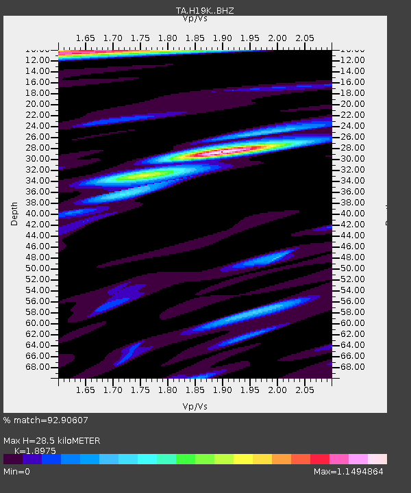
| Estimated Moho Depth: |
28.5 km |
| Estimated Crust Vp/Vs: |
1.90 |
| Assumed Crust Vp: |
6.182 km/s |
| Estimated Crust Vs: |
3.258 km/s |
| Estimated Crust Poisson's Ratio: |
0.31 |
|
| Radial Match: |
92.90607 % |
| Radial Bump: |
400 |
| Transverse Match: |
87.53778 % |
| Transverse Bump: |
400 |
| SOD ConfigId: |
21709731 |
| Insert Time: |
2020-08-10 17:47:09.482 +0000 |
| GWidth: |
2.5 |
| Max Bumps: |
400 |
| Tol: |
0.001 |
|

Signal To Noise
| Channel | StoN | STA | LTA |
| TA:H19K: :BHZ:20200727T17:44:00.14999Z | 26.32021 | 2.0184154E-6 | 7.66869E-8 |
| TA:H19K: :BHN:20200727T17:44:00.14999Z | 4.3973827 | 3.1065773E-7 | 7.064605E-8 |
| TA:H19K: :BHE:20200727T17:44:00.14999Z | 9.031301 | 7.092818E-7 | 7.8535955E-8 |
| Arrivals |
| Ps | 4.3 SECOND |
| PpPs | 13 SECOND |
| PsPs/PpSs | 17 SECOND |


