You are here: Home > Network List > TA - USArray Transportable Network (new EarthScope stations) Stations List
> Station H20K Anotleneega Mountain, AK, USA > Earthquake Result Viewer
H20K Anotleneega Mountain, AK, USA - Earthquake Result Viewer
| Earthquake location: |
Mindanao, Philippines |
| Earthquake latitude/longitude: |
9.0/126.3 |
| Earthquake time(UTC): |
2020/07/27 (209) 17:32:44 GMT |
| Earthquake Depth: |
39 km |
| Earthquake Magnitude: |
5.7 Mww |
| Earthquake Catalog/Contributor: |
NEIC PDE/us |
|
| Network: |
TA USArray Transportable Network (new EarthScope stations) |
| Station: |
H20K Anotleneega Mountain, AK, USA |
| Lat/Lon: |
65.49 N/154.88 W |
| Elevation: |
514 m |
|
| Distance: |
77.2 deg |
| Az: |
24.813 deg |
| Baz: |
263.604 deg |
| Ray Param: |
0.050412286 |
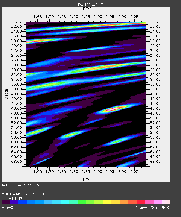
| Estimated Moho Depth: |
46.0 km |
| Estimated Crust Vp/Vs: |
1.96 |
| Assumed Crust Vp: |
6.566 km/s |
| Estimated Crust Vs: |
3.346 km/s |
| Estimated Crust Poisson's Ratio: |
0.32 |
|
| Radial Match: |
85.66776 % |
| Radial Bump: |
400 |
| Transverse Match: |
85.341545 % |
| Transverse Bump: |
400 |
| SOD ConfigId: |
21709731 |
| Insert Time: |
2020-08-10 17:47:09.827 +0000 |
| GWidth: |
2.5 |
| Max Bumps: |
400 |
| Tol: |
0.001 |
|

Signal To Noise
| Channel | StoN | STA | LTA |
| TA:H20K: :BHZ:20200727T17:44:03.750027Z | 26.007229 | 1.3563559E-6 | 5.2153034E-8 |
| TA:H20K: :BHN:20200727T17:44:03.750027Z | 3.9489903 | 2.3690862E-7 | 5.99922E-8 |
| TA:H20K: :BHE:20200727T17:44:03.750027Z | 9.515407 | 4.3849906E-7 | 4.608306E-8 |
| Arrivals |
| Ps | 6.9 SECOND |
| PpPs | 20 SECOND |
| PsPs/PpSs | 27 SECOND |


