You are here: Home > Network List > TA - USArray Transportable Network (new EarthScope stations) Stations List
> Station I28M Miner Creek, YT, CAN > Earthquake Result Viewer
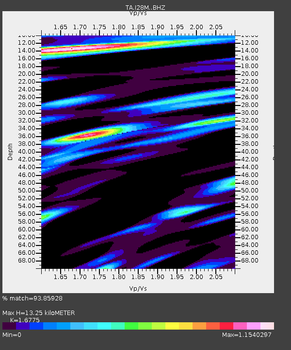
I28M Miner Creek, YT, CAN - Earthquake Result Viewer
| Earthquake location: |
Mindanao, Philippines |
| Earthquake latitude/longitude: |
9.0/126.3 |
| Earthquake time(UTC): |
2020/07/27 (209) 17:32:44 GMT |
| Earthquake Depth: |
39 km |
| Earthquake Magnitude: |
5.7 Mww |
| Earthquake Catalog/Contributor: |
NEIC PDE/us |
|
| Network: |
TA USArray Transportable Network (new EarthScope stations) |
| Station: |
I28M Miner Creek, YT, CAN |
| Lat/Lon: |
65.45 N/139.94 W |
| Elevation: |
1188 m |
|
| Distance: |
83.4 deg |
| Az: |
24.813 deg |
| Baz: |
277.198 deg |
| Ray Param: |
0.04613153 |
| Estimated Moho Depth: |
13.25 km |
| Estimated Crust Vp/Vs: |
1.68 |
| Assumed Crust Vp: |
6.566 km/s |
| Estimated Crust Vs: |
3.914 km/s |
| Estimated Crust Poisson's Ratio: |
0.22 |
|
| Radial Match: |
93.85928 % |
| Radial Bump: |
400 |
| Transverse Match: |
92.079285 % |
| Transverse Bump: |
400 |
| SOD ConfigId: |
21709731 |
| Insert Time: |
2020-08-10 17:47:18.342 +0000 |
| GWidth: |
2.5 |
| Max Bumps: |
400 |
| Tol: |
0.001 |
|

Signal To Noise
| Channel | StoN | STA | LTA |
| TA:I28M: :BHZ:20200727T17:44:37.074978Z | 47.35629 | 3.1903603E-6 | 6.736931E-8 |
| TA:I28M: :BHN:20200727T17:44:37.074978Z | 6.0799284 | 3.849136E-7 | 6.33089E-8 |
| TA:I28M: :BHE:20200727T17:44:37.074978Z | 19.504614 | 9.94013E-7 | 5.096297E-8 |
| Arrivals |
| Ps | 1.4 SECOND |
| PpPs | 5.3 SECOND |
| PsPs/PpSs | 6.7 SECOND |


