You are here: Home > Network List > TA - USArray Transportable Network (new EarthScope stations) Stations List
> Station K15K Wolf Creek Mountain, AK, USA > Earthquake Result Viewer
K15K Wolf Creek Mountain, AK, USA - Earthquake Result Viewer
| Earthquake location: |
Mindanao, Philippines |
| Earthquake latitude/longitude: |
9.0/126.3 |
| Earthquake time(UTC): |
2020/07/27 (209) 17:32:44 GMT |
| Earthquake Depth: |
39 km |
| Earthquake Magnitude: |
5.7 Mww |
| Earthquake Catalog/Contributor: |
NEIC PDE/us |
|
| Network: |
TA USArray Transportable Network (new EarthScope stations) |
| Station: |
K15K Wolf Creek Mountain, AK, USA |
| Lat/Lon: |
62.29 N/161.53 W |
| Elevation: |
346 m |
|
| Distance: |
73.8 deg |
| Az: |
27.606 deg |
| Baz: |
258.336 deg |
| Ray Param: |
0.052704703 |
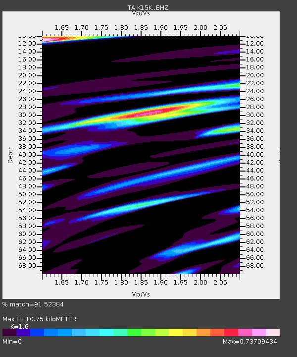
| Estimated Moho Depth: |
10.75 km |
| Estimated Crust Vp/Vs: |
1.60 |
| Assumed Crust Vp: |
6.276 km/s |
| Estimated Crust Vs: |
3.922 km/s |
| Estimated Crust Poisson's Ratio: |
0.18 |
|
| Radial Match: |
91.52384 % |
| Radial Bump: |
400 |
| Transverse Match: |
90.257614 % |
| Transverse Bump: |
400 |
| SOD ConfigId: |
21709731 |
| Insert Time: |
2020-08-10 17:47:30.033 +0000 |
| GWidth: |
2.5 |
| Max Bumps: |
400 |
| Tol: |
0.001 |
|

Signal To Noise
| Channel | StoN | STA | LTA |
| TA:K15K: :BHZ:20200727T17:43:44.27499Z | 24.768257 | 1.8589578E-6 | 7.505405E-8 |
| TA:K15K: :BHN:20200727T17:43:44.27499Z | 2.6055267 | 1.7910766E-7 | 6.8741436E-8 |
| TA:K15K: :BHE:20200727T17:43:44.27499Z | 9.286051 | 8.048639E-7 | 8.6674504E-8 |
| Arrivals |
| Ps | 1.1 SECOND |
| PpPs | 4.3 SECOND |
| PsPs/PpSs | 5.4 SECOND |


