You are here: Home > Network List > GO - National Seismic Network of Georgia Stations List
> Station TBLG Delisi, Georgia > Earthquake Result Viewer
TBLG Delisi, Georgia - Earthquake Result Viewer
*The percent match for this event was below the threshold and hence no stack was calculated.
| Earthquake location: |
Alaska Peninsula |
| Earthquake latitude/longitude: |
54.9/-160.3 |
| Earthquake time(UTC): |
2020/07/27 (209) 19:34:37 GMT |
| Earthquake Depth: |
39 km |
| Earthquake Magnitude: |
5.5 Mww |
| Earthquake Catalog/Contributor: |
NEIC PDE/us |
|
| Network: |
GO National Seismic Network of Georgia |
| Station: |
TBLG Delisi, Georgia |
| Lat/Lon: |
41.73 N/44.74 E |
| Elevation: |
510 m |
|
| Distance: |
81.4 deg |
| Az: |
341.324 deg |
| Baz: |
14.301 deg |
| Ray Param: |
$rayparam |
*The percent match for this event was below the threshold and hence was not used in the summary stack. |
|
| Radial Match: |
47.682526 % |
| Radial Bump: |
400 |
| Transverse Match: |
60.643147 % |
| Transverse Bump: |
400 |
| SOD ConfigId: |
21709731 |
| Insert Time: |
2020-08-10 19:40:21.376 +0000 |
| GWidth: |
2.5 |
| Max Bumps: |
400 |
| Tol: |
0.001 |
|
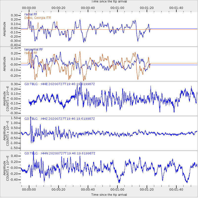
Signal To Noise
| Channel | StoN | STA | LTA |
| GO:TBLG: :HHZ:20200727T19:46:19.619987Z | 5.49536 | 5.219125E-7 | 9.497331E-8 |
| GO:TBLG: :HHN:20200727T19:46:19.619987Z | 1.709086 | 1.704296E-7 | 9.9719735E-8 |
| GO:TBLG: :HHE:20200727T19:46:19.619987Z | 2.0181265 | 1.3856402E-7 | 6.865973E-8 |
| Arrivals |
| Ps | |
| PpPs | |
| PsPs/PpSs | |


