You are here: Home > Network List > N4 - Central and EAstern US Network Stations List
> Station P61A Hammonton, NJ, USA > Earthquake Result Viewer
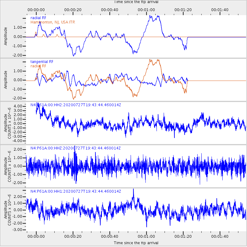
P61A Hammonton, NJ, USA - Earthquake Result Viewer
*The percent match for this event was below the threshold and hence no stack was calculated.
| Earthquake location: |
Alaska Peninsula |
| Earthquake latitude/longitude: |
54.9/-160.3 |
| Earthquake time(UTC): |
2020/07/27 (209) 19:34:37 GMT |
| Earthquake Depth: |
39 km |
| Earthquake Magnitude: |
5.5 Mww |
| Earthquake Catalog/Contributor: |
NEIC PDE/us |
|
| Network: |
N4 Central and EAstern US Network |
| Station: |
P61A Hammonton, NJ, USA |
| Lat/Lon: |
39.67 N/74.79 W |
| Elevation: |
22 m |
|
| Distance: |
56.3 deg |
| Az: |
67.569 deg |
| Baz: |
316.251 deg |
| Ray Param: |
$rayparam |
*The percent match for this event was below the threshold and hence was not used in the summary stack. |
|
| Radial Match: |
24.539215 % |
| Radial Bump: |
400 |
| Transverse Match: |
54.462566 % |
| Transverse Bump: |
400 |
| SOD ConfigId: |
21709731 |
| Insert Time: |
2020-08-10 19:44:34.586 +0000 |
| GWidth: |
2.5 |
| Max Bumps: |
400 |
| Tol: |
0.001 |
|
Signal To Noise
| Channel | StoN | STA | LTA |
| N4:P61A:00:HHZ:20200727T19:43:44.460014Z | 0.94760317 | 5.3822447E-7 | 5.6798507E-7 |
| N4:P61A:00:HH1:20200727T19:43:44.460014Z | 0.9813386 | 1.3355956E-6 | 1.3609936E-6 |
| N4:P61A:00:HH2:20200727T19:43:44.460014Z | 0.54789346 | 8.3883543E-7 | 1.5310192E-6 |
| Arrivals |
| Ps | |
| PpPs | |
| PsPs/PpSs | |


