You are here: Home > Network List > GS - US Geological Survey Networks Stations List
> Station KAN08 Pence Farm, Harper, KS, USA > Earthquake Result Viewer
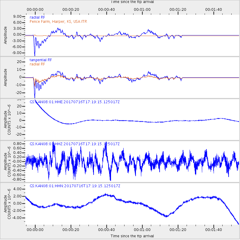
KAN08 Pence Farm, Harper, KS, USA - Earthquake Result Viewer
*The percent match for this event was below the threshold and hence no stack was calculated.
| Earthquake location: |
Tonga Islands |
| Earthquake latitude/longitude: |
-20.4/-173.5 |
| Earthquake time(UTC): |
2017/07/16 (197) 17:06:41 GMT |
| Earthquake Depth: |
10 km |
| Earthquake Magnitude: |
5.5 Mww |
| Earthquake Catalog/Contributor: |
NEIC PDE/us |
|
| Network: |
GS US Geological Survey Networks |
| Station: |
KAN08 Pence Farm, Harper, KS, USA |
| Lat/Lon: |
37.23 N/97.97 W |
| Elevation: |
375 m |
|
| Distance: |
91.2 deg |
| Az: |
50.614 deg |
| Baz: |
245.239 deg |
| Ray Param: |
$rayparam |
*The percent match for this event was below the threshold and hence was not used in the summary stack. |
|
| Radial Match: |
49.863483 % |
| Radial Bump: |
400 |
| Transverse Match: |
48.850372 % |
| Transverse Bump: |
400 |
| SOD ConfigId: |
2140511 |
| Insert Time: |
2017-07-30 09:02:30.911 +0000 |
| GWidth: |
2.5 |
| Max Bumps: |
400 |
| Tol: |
0.001 |
|
Signal To Noise
| Channel | StoN | STA | LTA |
| GS:KAN08:01:HHZ:20170716T17:19:15.125017Z | 0.84129655 | 1.7652376E-7 | 2.0982347E-7 |
| GS:KAN08:01:HHN:20170716T17:19:15.125017Z | 0.38942692 | 3.5856451E-6 | 9.2074915E-6 |
| GS:KAN08:01:HHE:20170716T17:19:15.125017Z | 0.36162877 | 3.5439423E-6 | 9.7999455E-6 |
| Arrivals |
| Ps | |
| PpPs | |
| PsPs/PpSs | |


