You are here: Home > Network List > US - United States National Seismic Network Stations List
> Station MNTX Cornudas Mountains, Texas, USA > Earthquake Result Viewer
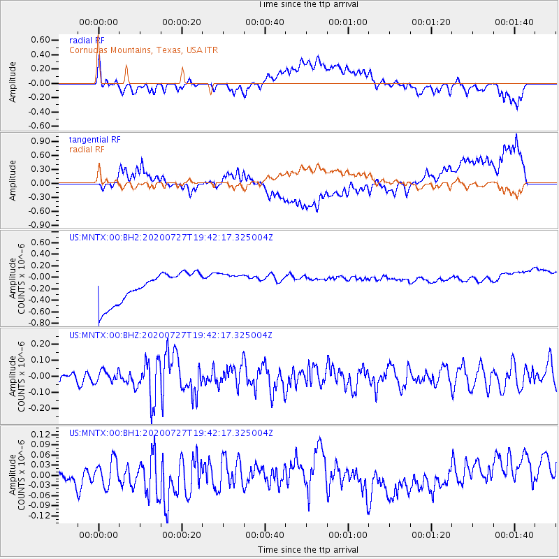
MNTX Cornudas Mountains, Texas, USA - Earthquake Result Viewer
*The percent match for this event was below the threshold and hence no stack was calculated.
| Earthquake location: |
Alaska Peninsula |
| Earthquake latitude/longitude: |
54.9/-160.3 |
| Earthquake time(UTC): |
2020/07/27 (209) 19:34:37 GMT |
| Earthquake Depth: |
39 km |
| Earthquake Magnitude: |
5.5 Mww |
| Earthquake Catalog/Contributor: |
NEIC PDE/us |
|
| Network: |
US United States National Seismic Network |
| Station: |
MNTX Cornudas Mountains, Texas, USA |
| Lat/Lon: |
31.70 N/105.38 W |
| Elevation: |
404 m |
|
| Distance: |
44.8 deg |
| Az: |
98.019 deg |
| Baz: |
317.876 deg |
| Ray Param: |
$rayparam |
*The percent match for this event was below the threshold and hence was not used in the summary stack. |
|
| Radial Match: |
22.891169 % |
| Radial Bump: |
400 |
| Transverse Match: |
21.616766 % |
| Transverse Bump: |
400 |
| SOD ConfigId: |
21709731 |
| Insert Time: |
2020-08-10 19:51:13.346 +0000 |
| GWidth: |
2.5 |
| Max Bumps: |
400 |
| Tol: |
0.001 |
|
Signal To Noise
| Channel | StoN | STA | LTA |
| US:MNTX:00:BHZ:20200727T19:42:17.325004Z | 0.74453145 | 3.5060147E-8 | 4.7090218E-8 |
| US:MNTX:00:BH1:20200727T19:42:17.325004Z | 0.8356642 | 3.855005E-8 | 4.6131028E-8 |
| US:MNTX:00:BH2:20200727T19:42:17.325004Z | 0.806949 | 2.1032663E-7 | 2.6064427E-7 |
| Arrivals |
| Ps | |
| PpPs | |
| PsPs/PpSs | |


