You are here: Home > Network List > WY - Yellowstone Wyoming Seismic Network Stations List
> Station YHH Holmes Hill, YNP, WY, USA > Earthquake Result Viewer
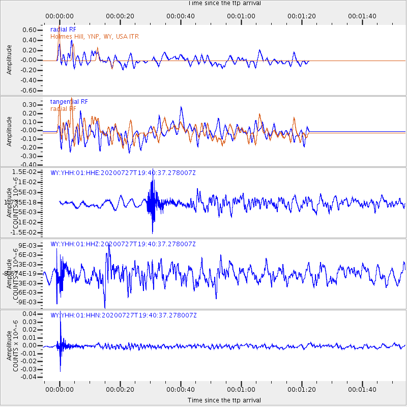
YHH Holmes Hill, YNP, WY, USA - Earthquake Result Viewer
*The percent match for this event was below the threshold and hence no stack was calculated.
| Earthquake location: |
Alaska Peninsula |
| Earthquake latitude/longitude: |
54.9/-160.3 |
| Earthquake time(UTC): |
2020/07/27 (209) 19:34:37 GMT |
| Earthquake Depth: |
39 km |
| Earthquake Magnitude: |
5.5 Mww |
| Earthquake Catalog/Contributor: |
NEIC PDE/us |
|
| Network: |
WY Yellowstone Wyoming Seismic Network |
| Station: |
YHH Holmes Hill, YNP, WY, USA |
| Lat/Lon: |
44.79 N/110.85 W |
| Elevation: |
2717 m |
|
| Distance: |
32.8 deg |
| Az: |
87.112 deg |
| Baz: |
305.923 deg |
| Ray Param: |
$rayparam |
*The percent match for this event was below the threshold and hence was not used in the summary stack. |
|
| Radial Match: |
56.667347 % |
| Radial Bump: |
400 |
| Transverse Match: |
58.4839 % |
| Transverse Bump: |
400 |
| SOD ConfigId: |
21709731 |
| Insert Time: |
2020-08-10 19:52:28.322 +0000 |
| GWidth: |
2.5 |
| Max Bumps: |
400 |
| Tol: |
0.001 |
|
Signal To Noise
| Channel | StoN | STA | LTA |
| WY:YHH:01:HHZ:20200727T19:40:37.278007Z | 1.7927022 | 2.5610785E-9 | 1.4286134E-9 |
| WY:YHH:01:HHN:20200727T19:40:37.278007Z | 5.3311553 | 7.2017516E-9 | 1.3508801E-9 |
| WY:YHH:01:HHE:20200727T19:40:37.278007Z | 3.1081562 | 4.527754E-9 | 1.4567332E-9 |
| Arrivals |
| Ps | |
| PpPs | |
| PsPs/PpSs | |


