You are here: Home > Network List > IC - New China Digital Seismograph Network Stations List
> Station BJT Baijiatuan, Beijing, China > Earthquake Result Viewer
BJT Baijiatuan, Beijing, China - Earthquake Result Viewer
| Earthquake location: |
Tonga Islands |
| Earthquake latitude/longitude: |
-20.4/-173.5 |
| Earthquake time(UTC): |
2017/07/16 (197) 17:06:41 GMT |
| Earthquake Depth: |
10 km |
| Earthquake Magnitude: |
5.5 Mww |
| Earthquake Catalog/Contributor: |
NEIC PDE/us |
|
| Network: |
IC New China Digital Seismograph Network |
| Station: |
BJT Baijiatuan, Beijing, China |
| Lat/Lon: |
40.02 N/116.17 E |
| Elevation: |
197 m |
|
| Distance: |
88.9 deg |
| Az: |
313.655 deg |
| Baz: |
117.931 deg |
| Ray Param: |
0.04225375 |
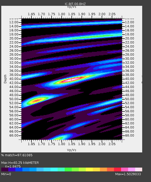
| Estimated Moho Depth: |
40.25 km |
| Estimated Crust Vp/Vs: |
1.85 |
| Assumed Crust Vp: |
6.464 km/s |
| Estimated Crust Vs: |
3.499 km/s |
| Estimated Crust Poisson's Ratio: |
0.29 |
|
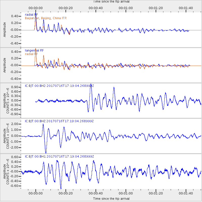
| Radial Match: |
97.61065 % |
| Radial Bump: |
400 |
| Transverse Match: |
91.154816 % |
| Transverse Bump: |
366 |
| SOD ConfigId: |
2140511 |
| Insert Time: |
2017-07-30 09:03:25.467 +0000 |
| GWidth: |
2.5 |
| Max Bumps: |
400 |
| Tol: |
0.001 |
|
Signal To Noise
| Channel | StoN | STA | LTA |
| IC:BJT:00:BHZ:20170716T17:19:04.268999Z | 8.253226 | 4.617078E-7 | 5.5942706E-8 |
| IC:BJT:00:BH1:20170716T17:19:04.268999Z | 1.342633 | 6.452246E-8 | 4.805666E-8 |
| IC:BJT:00:BH2:20170716T17:19:04.268999Z | 3.253152 | 1.3919804E-7 | 4.2788667E-8 |
| Arrivals |
| Ps | 5.4 SECOND |
| PpPs | 17 SECOND |
| PsPs/PpSs | 23 SECOND |


