You are here: Home > Network List > AG - Arkansas Seismic Network Stations List
> Station U40A Yellville, AR > Earthquake Result Viewer
U40A Yellville, AR - Earthquake Result Viewer
| Earthquake location: |
Alaska Peninsula |
| Earthquake latitude/longitude: |
54.8/-161.2 |
| Earthquake time(UTC): |
2020/07/28 (210) 08:03:44 GMT |
| Earthquake Depth: |
60 km |
| Earthquake Magnitude: |
5.9 Mi |
| Earthquake Catalog/Contributor: |
NEIC PDE/at |
|
| Network: |
AG Arkansas Seismic Network |
| Station: |
U40A Yellville, AR |
| Lat/Lon: |
36.36 N/92.85 W |
| Elevation: |
374 m |
|
| Distance: |
49.2 deg |
| Az: |
82.501 deg |
| Baz: |
314.64 deg |
| Ray Param: |
0.068728596 |
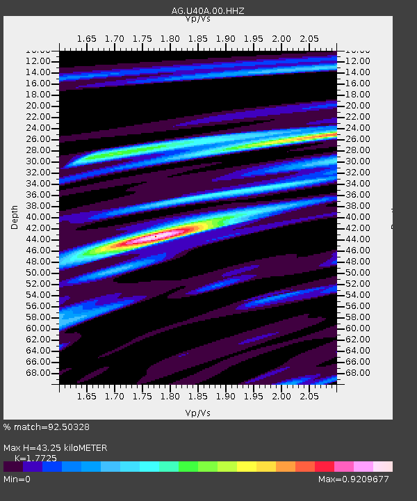
| Estimated Moho Depth: |
43.25 km |
| Estimated Crust Vp/Vs: |
1.77 |
| Assumed Crust Vp: |
6.53 km/s |
| Estimated Crust Vs: |
3.684 km/s |
| Estimated Crust Poisson's Ratio: |
0.27 |
|
| Radial Match: |
92.50328 % |
| Radial Bump: |
387 |
| Transverse Match: |
79.95984 % |
| Transverse Bump: |
400 |
| SOD ConfigId: |
21709731 |
| Insert Time: |
2020-08-11 08:04:45.288 +0000 |
| GWidth: |
2.5 |
| Max Bumps: |
400 |
| Tol: |
0.001 |
|
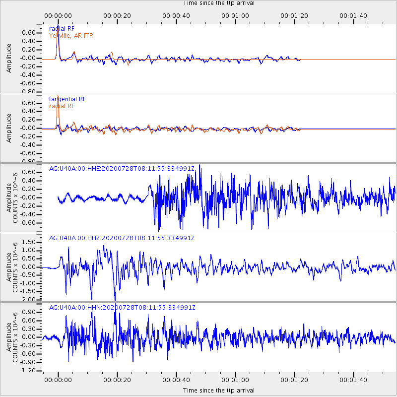
Signal To Noise
| Channel | StoN | STA | LTA |
| AG:U40A:00:HHZ:20200728T08:11:55.334991Z | 13.050271 | 5.569989E-7 | 4.268102E-8 |
| AG:U40A:00:HHN:20200728T08:11:55.334991Z | 6.891007 | 3.0029176E-7 | 4.3577337E-8 |
| AG:U40A:00:HHE:20200728T08:11:55.334991Z | 4.9987364 | 2.6669167E-7 | 5.3351815E-8 |
| Arrivals |
| Ps | 5.4 SECOND |
| PpPs | 17 SECOND |
| PsPs/PpSs | 23 SECOND |


