You are here: Home > Network List > CA - Catalan Seismic Network Stations List
> Station CFON Fontmartina > Earthquake Result Viewer
CFON Fontmartina - Earthquake Result Viewer
| Earthquake location: |
Alaska Peninsula |
| Earthquake latitude/longitude: |
54.8/-161.2 |
| Earthquake time(UTC): |
2020/07/28 (210) 08:03:44 GMT |
| Earthquake Depth: |
60 km |
| Earthquake Magnitude: |
5.9 Mi |
| Earthquake Catalog/Contributor: |
NEIC PDE/at |
|
| Network: |
CA Catalan Seismic Network |
| Station: |
CFON Fontmartina |
| Lat/Lon: |
41.76 N/2.43 E |
| Elevation: |
973 m |
|
| Distance: |
82.8 deg |
| Az: |
12.295 deg |
| Baz: |
350.509 deg |
| Ray Param: |
0.046517286 |
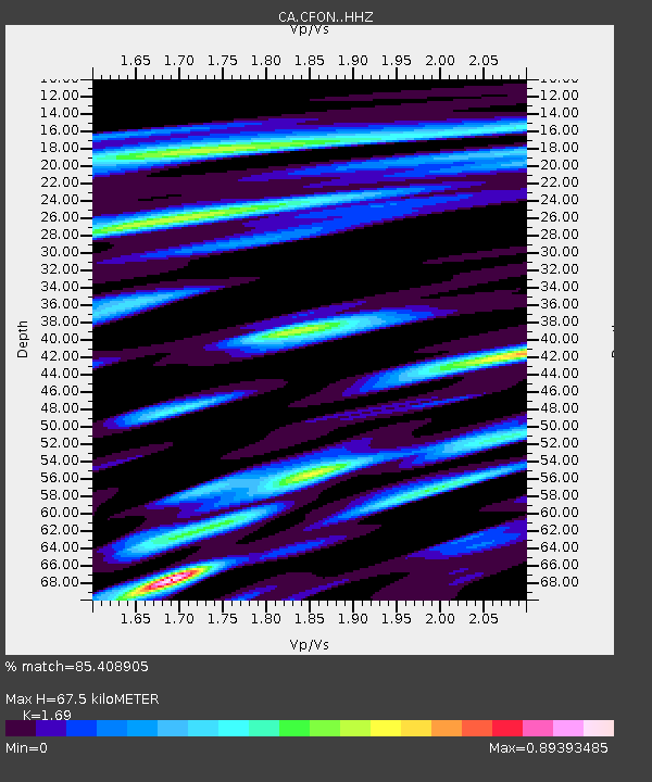
| Estimated Moho Depth: |
67.5 km |
| Estimated Crust Vp/Vs: |
1.69 |
| Assumed Crust Vp: |
5.88 km/s |
| Estimated Crust Vs: |
3.48 km/s |
| Estimated Crust Poisson's Ratio: |
0.23 |
|
| Radial Match: |
85.408905 % |
| Radial Bump: |
400 |
| Transverse Match: |
69.86229 % |
| Transverse Bump: |
400 |
| SOD ConfigId: |
21709731 |
| Insert Time: |
2020-08-11 08:06:03.947 +0000 |
| GWidth: |
2.5 |
| Max Bumps: |
400 |
| Tol: |
0.001 |
|

Signal To Noise
| Channel | StoN | STA | LTA |
| CA:CFON: :HHZ:20200728T08:15:30.669983Z | 7.2811728 | 6.9637326E-7 | 9.564026E-8 |
| CA:CFON: :HHN:20200728T08:15:30.669983Z | 3.90874 | 2.9625937E-7 | 7.5794084E-8 |
| CA:CFON: :HHE:20200728T08:15:30.669983Z | 1.0090444 | 8.4688E-8 | 8.392892E-8 |
| Arrivals |
| Ps | 8.1 SECOND |
| PpPs | 30 SECOND |
| PsPs/PpSs | 38 SECOND |


