You are here: Home > Network List > CN - Canadian National Seismograph Network Stations List
> Station A54 Misere, QC, CA > Earthquake Result Viewer
A54 Misere, QC, CA - Earthquake Result Viewer
| Earthquake location: |
Alaska Peninsula |
| Earthquake latitude/longitude: |
54.8/-161.2 |
| Earthquake time(UTC): |
2020/07/28 (210) 08:03:44 GMT |
| Earthquake Depth: |
60 km |
| Earthquake Magnitude: |
5.9 Mi |
| Earthquake Catalog/Contributor: |
NEIC PDE/at |
|
| Network: |
CN Canadian National Seismograph Network |
| Station: |
A54 Misere, QC, CA |
| Lat/Lon: |
47.46 N/70.41 W |
| Elevation: |
377 m |
|
| Distance: |
53.6 deg |
| Az: |
57.472 deg |
| Baz: |
313.963 deg |
| Ray Param: |
0.06583971 |
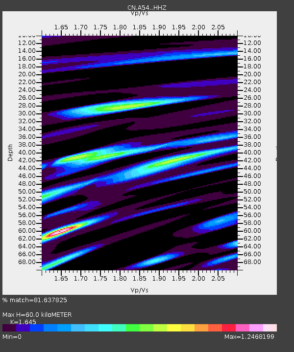
| Estimated Moho Depth: |
60.0 km |
| Estimated Crust Vp/Vs: |
1.64 |
| Assumed Crust Vp: |
6.61 km/s |
| Estimated Crust Vs: |
4.018 km/s |
| Estimated Crust Poisson's Ratio: |
0.21 |
|
| Radial Match: |
81.637825 % |
| Radial Bump: |
382 |
| Transverse Match: |
60.220364 % |
| Transverse Bump: |
400 |
| SOD ConfigId: |
21709731 |
| Insert Time: |
2020-08-11 08:08:15.928 +0000 |
| GWidth: |
2.5 |
| Max Bumps: |
400 |
| Tol: |
0.001 |
|

Signal To Noise
| Channel | StoN | STA | LTA |
| CN:A54: :HHZ:20200728T08:12:28.390015Z | 6.2104893 | 6.5096424E-7 | 1.04816905E-7 |
| CN:A54: :HHN:20200728T08:12:28.390015Z | 1.9201392 | 2.0540143E-7 | 1.0697216E-7 |
| CN:A54: :HHE:20200728T08:12:28.390015Z | 2.5363612 | 2.564037E-7 | 1.0109115E-7 |
| Arrivals |
| Ps | 6.2 SECOND |
| PpPs | 23 SECOND |
| PsPs/PpSs | 29 SECOND |


